Early this morning, it appears the setup for possible tornadoes in south-central KS still looks pretty good. In fact, I think it looks really good! I just took a look at the 09z RUC 12-hour forecast for 21z, and I am pleased to see that it matches the NAM forecast pretty good in most of the fields supporting "cold-core" surface-based severe convection. The only difference is positioning of the fields. The 00z NAM forecast was a bit farther south from previous runs, however the 09z RUC is very similar to the previous NAM runs (farther north along Highway 54 corridor). Below are a few of the 09z RUC figures I put together to illustrate:
Figure 1. 12-hour forecast of surface wind and dewpoint from the 09z run of the RUC model. The region I am most interested is encircled dotted-black. I observed tornadoes both on 26 October 2006 and 10 November 2008 in this same area, conceptually speaking in terms of the surface wind and dewpoint fields. The western nose of the dewpoint/Theta-E field at the point of maximum surface vertical vorticity is the "place to be", in my opinion, for observing (a) tornado(es) given the tremendous source of vorticity and baroclinicity a storm has to work with. There will be a southeastward extension of this rich vertical vorticity along the occluded front, so as additional storms form southeast by late afternoon/early evening, there may be several storms producing tornadoes along the surface occluded front. I feel quite confident the occluded front will be very productive! 500mb Temperatures are also shown in this figure. Note how far east the -20C isotherm extends!

Figure 2. The 12-hour RUC is generating convection in the exact area I expected it to, which leads confidence in the forecast for (a) severe storm(s) with tornado prospects. This is even farther west than I was thinking yesterday, should this be a perfect prog. Model forecast CAPE is higher than I typically see for the true "cold-core" events, with the RUC suggesting near 1000 J/kg CAPE nosing as far west as Stafford County, KS!. Usually model CAPE doesn’t capture the true surface-based instability for these events very well. This could be a signal that today could be a very productive "cold-core" day.
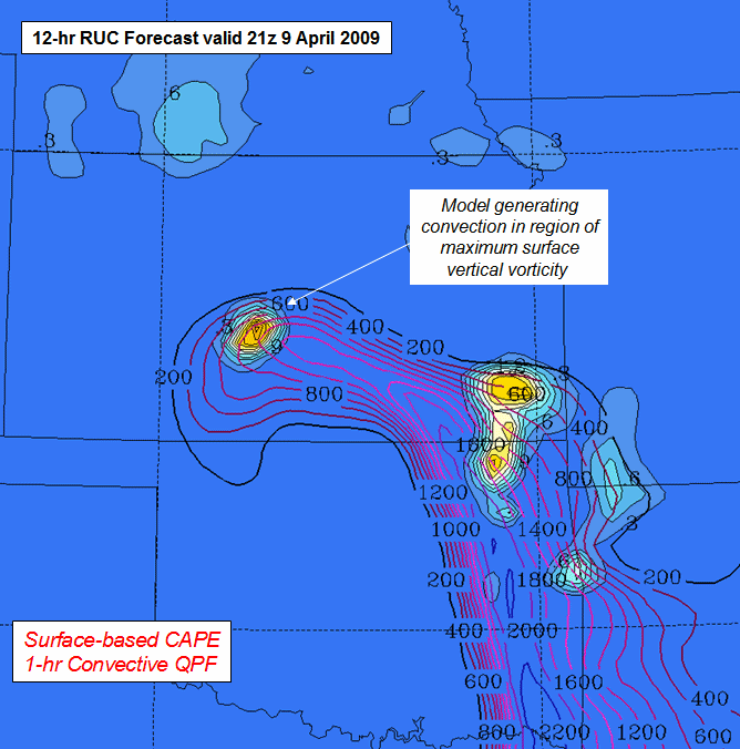
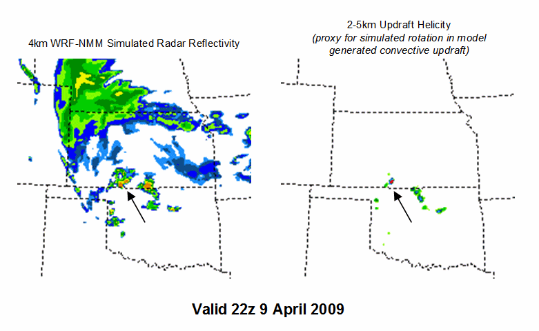
Figure 3. The 00z run of the 4km WRF-NMM is interesting. Hourly graphics of the simulated radar reflectivity show intense convection developing as far west as Coldwater-Medicine Lodge, KS at 22z… Wow! They may have to watch this closely at work (NWSFO Dodge City, KS) for our eastern counties from in the 21-22z time frame. I am scheduled to go into work at 21z!
So, the 64-thousand dollar question. Where would Mike target if he wasn’t at work this afternoon/evening?
Pratt, KS by Noon and watching the sky/visible satellite/observations/short-fuse composite very closely, with eyes set east (or east-northeast or east-southeast??) of Pratt for the 21-22z time frame!
Excellent forecast, as always!
Comment by Chad C — April 9, 2009 @ 7:08 am
Mike! You ‘da Man! I’ll be heading out to Kingman to stage as I chase for Ch. 12. Send me an email and I will give you more details. Besides, we need to catch up and find out just how good you’re getting with average!
The Ferg
Comment by Lance F. — April 9, 2009 @ 8:09 am
Can’t chase today, but appreciate the “heads-up” and will be watching the DDC Shortfuse Composite today just to torture myself! Thanks Mike!
Comment by Darren Addy — April 9, 2009 @ 10:02 am
It’s almost 19:00 Z, so what looks like a good area now?
Comment by Jim Smiley — April 9, 2009 @ 12:59 pm
Id like to see an equally nice analysis of what went wrong. Bosart’s Law, perhaps
Comment by Stan R. — April 10, 2009 @ 12:20 am