This morning’s model runs suggest a trend to the north and west with heavy snow axis. The new 12z runs of the NAM, GFS, and even the Canadian GEM support a scenario which includes areas like Wichita and Kansas City for heavy snow. The mid level PV anomaly is now expected to lift out in a more northerly direction given the very cold upstream disturbance digging south in its wake which will act to pivot the main lead wave out sooner and in a more northerly direction. In fact, the 12z runs may still be playing catch up to what may eventually happen, and if that’s the case, then the main lead PV anomaly will undergo development even quicker and lift out north-northeasterly into Kansas! If this does happen, then development at 700mb will occur faster and farther west, which is good for decent accumulating snow in Dodge City. The trends look “up” right now for portions of southwest and especially south-central Kansas. It still looks like the real major heavy snow axis will be across the eastern Great Plains into the Mid-Mississippi Valley, but this heavy snow axis will likely be farther north and a bit west than what Post #2 indicated. Major snowfall of 12″ or greater will occur in the heavy snow axis, which at this time, now looks to include Kansas City and points northeast of there through Quincy, MO and up to Chicago. The heavy snow axis of 5 to 8″ may begin as far southwest as Northwestern Oklahoma, which is getting closer to Dodge City, and there is still time for the westward trend to continue to perhaps include Dodge City. Right now, I am expecting 1 to 3″ in Dodge City, but that is with very low confidence given the instability in the model depiction of heavy QPF axes.

Figure 1. Last night’s GFS run did not show much development at 700mb south of Dodge City. The wind fields did not show a tremendous amount of convergence and/or deformation which is necessary for good upward vertical motion.

Figure 2. This morning’s GFS run, however, does show better development at 700mb south of Dodge City, which is directly tied to better jet streak dynamics and a more robust development at 500mb

Figure 3. 500mb Temperature and Wind forecast from this morning’s GFS run. White arrows depict the individual jet streaks at 500mb. Check out the cold air at 500mb across the northern Rockies — a very anomalous -40C in eastern Montana! This will lead to stronger cold advection into the base of the trough and subsequently more vigorous mid level cyclonic development. The track of the mid level PV anomaly is in yellow as per the GFS. The Canadian model is very similar with this track. Heavy snow almost always occurs just north of the mid level PV track, which is where frontogenesis and westward extension of the warm conveyor (a.k.a. the “TROWAL”) sets up. If this track pans out, heavy snow is most likely from Northwest Oklahoma through south-central Kansas to east-central Kansas — major cities like Wichita and Kansas City being in this track.

Figure 4.

Figure 5.
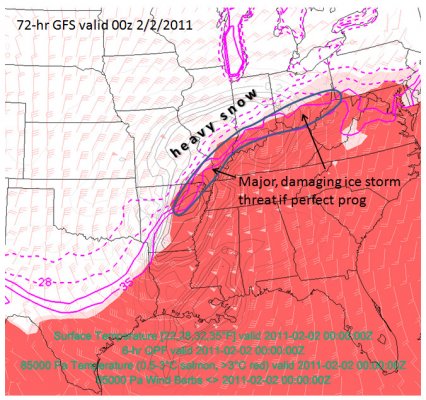
An I-44 & Ohio Valley Special! The Feb 1-2 storm coming up will be rather impressive. Actually really impressive. It’s a classic meet-and-greet of very cold, arctic air and an unrestricted, rich Gulf of Mexico moisture source. A true “Clash of the Airmasses”. (Yes, this is the worst pseudo-meteorological idiom ever). At any rate, this storm is interesting enough to me to blog about, despite it not really affecting Southwest Kansas much. I usually only blog about the western Great Plains storms, but given the dearth of winter precipitation events out here this season, I was itching to write about something. At least we’ll see the cold air component here in Dodge City (as was the focus of post #1 of this series), and perhaps an inch of snow. But the real story will be farther east…where areas like Tulsa, Springfield MO, Saint Louis, Indianapolis, and Cincinnati will see some rather phenomenal winter precipitation whether it be heavy snow, sleet, or freezing rain (or a combination of the three to some degree). There should be a 50-100 mile wide swath of potentially very damaging icing from eastern Oklahoma through northern Arkansas into portions of southeastern Missouri and then northeast along the Ohio River (give or take). This is the classical corridor for major ice storms. Immediately north of the sleet/freezing rain, both the NAM and GFS indicate the potential for heavy snow accumulation of 15 to 24 inches. It is interesting that, even at 60-72 hours out, both the models show a similar storm total snow axis and magnitude. See Figures 1 and 2 below. In Figure 3, I created a composite chart using IDV (Integrated Data Viewer) and GFS grids showing the forecast warm layer aloft, centered roughly around 850mb (the salmon and red shading area) along with surface temperature isotherms of 22, 28, 32, 35°F which reveals the forecast overlap of these fields indicating the best area for sleet/freezing rain (model uncertainties at this time frame understood, of course). It looks like my friends and family in Kansas City will be on the northwestern fringes of this storm, but it wouldn’t take much of a shift to the north… and for the storm to mature faster… to bring Kansas City into play for some serious accumulating winter precipitation.

Figure 1.

Figure 2.

Figure 3.
Dramatic changes coming to the Central/Southern Plains, Mid-Mississippi Valley region. A substantial arctic air intrusion is expected next Tuesday and Wednesday. In addition, a decent portion of the Central U.S. will see some major winter precipitation, including freezing rain, sleet, and snow. A mid-latitude cyclone will mature at the boundary of the arctic airmass leading to a widespread winter storm event. It looks like the most substantial winter precipitation will extend from Oklahoma through Missouri and east toward the Ohio Valley/lower Great Lakes region. We saw a high of 71 in Dodge City on Friday, January 28th, which was only a few degrees from a record high for the date. 4-days later, on Tuesday, February 1, the late afternoon temperature in Dodge City will likey be around 10°F!

Figure 1. Surface map as depicted by the 3-hr NAM forecast showing the 70s in Southwest Kansas on Friday, 1/28

Figure 2. Surface map as depicted by the 69-hr NAM forecast showing temperatures in the teens in Southwest Kansas on Tuesday afternoon, 2/1

Figure 3. Official NWS forecasts for Dodge City, Kansas City, Springfield MO, and Norman OK for the upcoming winter weather event for next week. A winter storm watch is already in effect for Kansas City and Springfield MO.
The “haves” and the “have nots” — The storm is coming out across the Rockies in pieces — not good for heavy snow in Dodge City. My updated thinking is 1-3″ in Dodge City for this event. We’ve started to get some very light snow here at my house just north of town, but only a dusting of accumulation so far. The expected cyclogenesis from the surface to about 700mb just isn’t going to take shape like earlier expected, and as such, only periods of light (maybe moderate at times) snow will occur through Monday. Since the storm will not be as developed for southwest Kansas, the winds behind the low will not be as strong, so the blowing and drifting component will also likely be less than I previously thought. Unless radar echoes blossom in the area highlighted in Figure 2 (associated with the “x” near the Colorado-Utah border as shown in Figure 1) through the night, then this just isn’t going to happen for most of Southwest Kansas along and south of Highway 50. The Hays and Wakeeney areas have already seen an inch or two of snow with the first little mesoscale wave while we were left high and dry in Dodge for the most part. Yet another “blah” event it would appear.

Figure 1

Figure 2
Meanwhile, the real excitement isn’t even occurring across the Central Plains, but in the Southeast. A major ice and snow storm is underway across much of the Gulf Coast/Southeast region (except for near the coast where it’s warm enough for all rain):

Figure 3

Figure 4
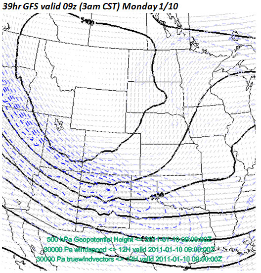
Accumulating snow, strong winds, and cold temps headed for Southwest Kansas. We are within 30 hours of the beginning of a winter storm to affect western Kansas. I have been working midnight shifts working this event at the Dodge City NWSFO, but the time has come to begin blogging a little bit about the storm. I think we’ll see 5 to 7″ of snow in Dodge City… that is my own personal prediction at this point based on the latest forecast track/strength of the approaching storm from various model inputs. Figure 1 shows the MSLP and surface wind pattern. Note the surface circulation from near Gage, OK to Childress, TX. This good for moderate/heavy snow for much of Southwest Kansas. This low level development is going to form in the left exit region of an upper level jet streak, which is shown in blue in Figure 2. The jet streak dynamics will be quite good. Winds will shift at the surface from southeast to northeast Monday morning…then to the north and increasing 20-30 mph by midday in Dodge City. Substantial blowing and drifting snow will occur across much of Southwest Kansas. The ECMWF model has pegged this for a number of runs now, and the NCEP models are finally trying to catch up with the ECMWF regarding the magnitude of wind and cold behind the front. Monday will be quite brutal around Dodge City.

Figure 1

Figure 2
1.4″ at my house 5 miles north of Dodge City. Some areas outside of Dodge City, mainly west, received upwards of 3 inches. 1.8″ was measured at the airport, which brings the season snow total to a whopping 2.0″! LOL. Anyway, here are a few photos I took from earlier this morning:
1.1″ snowfall at my house 5 N Dodge City as of 1:00am CST on December 31, 2010… making it the first inch of the season! Moderate to heavy snow began during the last hour of my shift at NWS Dodge City. On the official midnight observation, we measured 0.5″, which all fell during that last hour. On the drive home, moderate-heavy snow continued as the last band of heavy snow was positioned over Dodge City (Figure 1). We may get up to 2 inches, depending on how long this last band hangs around and/or redevelops back west a bit.

Figure 1
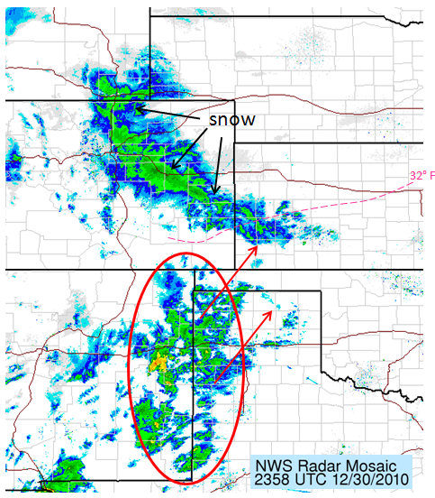
Wintry precipitation to impact much of Southwest Kansas, including Dodge City, tonight. This is a quick update on things on my blog while I’m at work in between updating official products here at WFO Dodge City. Radar shows precipitation blossoming across eastern New Mexico and West Texas (Figure 1) ahead of the developing upper low. The precipitation echoes on radar are not too bad considering the scant moisture across West Texas. The leading edge of the arctic airmass is making a fast run on Dodge City. Temperatures are crashing fast. It will be below 32°F here in Dodge City 8 or 9pm…with temperatures falling fast through the remainder of the night. Precipitation will begin as a mix of freezing rain and sleet… then becoming sleet and snow. The RUC and HRRR show as much as a quarter inch of total QPF close to Dodge City with heavier QPF amounts northwest of here. A winter weather advisory is in effect for much of Southwest Kansas (Figure 2).

Figure 1

Figure 2
Interesting cold, convective precipitation in Dodge City tonight? The cold front is on it’s way (Figure 2)! A lead wave (water vapor in Figure 1) was lifting north across Nebraska late this morning which is providing portions of central/northern Nebraska with a priming coat of snow before the bigger storm (the ‘x’ over Arizona in Figure 1) impacts the region tonight into New Years Eve. It still looks like some substantial snow accumulations up in the area from northern Nebraska into the eastern Dakotas once the upper low deepens during the day Friday north of here (southwest Kansas).
This post will focus on southwest Kansas… particularly here in Dodge City. I kind of look at this as a pre-brief for myself and what I have to look forward to on my evening shift tonight (4pm to midnight). The precipitation event for Dodge City will be tonight…particularly after about 8:00pm or so… and continuing until probably 3:00am or so? I took a look at the various high resolution model forecast composite reflectivity images (HRRR, 4km WRF NMM, 12km NAM) and the precipitation in Dodge City will be convective in nature (Figure 3) with some potential instability present at the nose of the mid level potential vorticity anomaly. The question will be how cold it will be. The arctic air is really not all that far away, and by the time the precipitation starts, the 30°F line will be precariously close to Dodge City (see bottom-right panel in Figure 3). The very leading edge of the arctic air will probably be shallow enough such that a warm layer aloft will exist and precipitation type may be either freezing rain or sleet… at least for a brief time…until we get far enough on the cold side of the arctic airmass. It’s really anybody’s guess as to how wide this corridor will be… but some convective sleet and freezing rain is certainly a distinct possibility tonight in and around Dodge City.

Figure 1

Figure 2

Figure 3
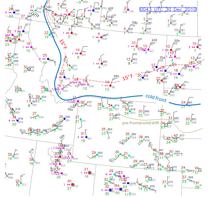
Bitter cold airmass is on the way. Winter Storm Warnings & Blizzard Warnings issued for portions of the High Plains, Northern & Central Plains. There isn’t a whole lot to update with this post. A bitterly cold airmass will envelop much of the Great Plains at the onset of snow across northeastern Colorado through Nebraska and into the Dakotas. In fact, temperatures Friday will hover around 0-5° F to go along with the moderate to heavy snow across portions of Nebraska and South Dakota. As if that wasn’t enough, north winds will range 20 to 30 mph with gusts frequently in the 35-40 mph range from western Nebraska through much of central and eastern South Dakota. This could turn out to be a nasty blizzard for a good portion of the northern Plains. As for closer to home in western Kansas, the bitter airmass will be the headline with afternoon temperatures in the single digits and teens. Accumulating snow will probably make it as far south as I-70, but unless the storm track makes an unanticipated shift to the south, much of Southwest Kansas will miss out on accumulating snow.
Figure 1 shows the surface map across the northern High Plains as of 6pm CST.
Figure 2 shows two NWS forecasts for the upcoming storm. The top is Hays, Kansas and the bottom is Valentine, NE. Notice the radical change in high temperature from Thursday to Friday at Hays!

Figure 1

Figure 2

Figure 3


