High Plains Drifter


disclaimer:  "The meteorological views/forecast thinking expressed are those solely of the author of this blog
and do not necessarily represent those of official National Weather Service forecast products,
therefore read and enjoy at your own risk and edification!"

October 10, 2005

Oct 9-11 Snow chase [post 3]

… 3.3 inches as of 230am MDT …

I have uploaded a few photos at http://www.underthemeso.com/gallery2/stormchase/chase05/2005oct10/

I found a decent measuring spot on a trailer bed that is elevated off the ground. Some melting and settling will make measuring difficult, but still think a solid foot to foot and a half is a good possibility by midnight tonight. The strongest lift will be continuing through mid afternoon. I’m gonna catch some Z’s for about 5 or 6 hours…and by the time I wake up, there should be about 3 or 4 more inches accumulation.

October 9, 2005

Oct 9-11 Snow chase [post 2]

Filed under: Chase Accounts,General Weather & Forecasting,Storm Chasing — Mike U @ 10:05 pm

9pm MDT. I have been in Castle Rock for an hour now and when I arrived the temperature was 38 degrees with light rain. As of the time of this writing, I look out the window and see quite a few small flakes… so we have changed over. There is a huge area of moderate to heavy precip to the southeast that is moving northwest towards my area. This should be the beginning of “the show” for the urban corridor. I sit here at 6200 feet. The latest NAM brings the total QPF down just a little bit, but still an impressive amount of snow no matter how you slice it. A good foot and a half still looks good here in Castle Rock! -Mu

Oct 9-11 Snow chase [post 1]

…Columbus Day Snow Chase — Castle Rock, CO…

Greetings everyone! Well this is a first for me. I have never done a snow chase before, but the timing couldn’t have been more perfect for me. I have both Columbus Day and Tuesday off, which coincides perfect with the timing of what looks to be a major snowstorm for the Colorado “urban corridor”. Both the GFS and the NAM models suggest upwards of two feet of snow south and southwest of Denver by late Monday Night or early Tuesday. Given the unusual early timing of such a powerful snow storm for this area, it may present some problems with numerous trees coming down as many of them have not lost their leaves yet.

I plan to leave Dodge City this afternoon around 2:30pm (Central time) and expect to arrive at my destination of Castle Rock, CO around 7:00pm (Mountain time). It should be raining by the time I get there, but rapidly change to snow sometime between 8pm and 10pm Mountain time. It may even changeover before I arrive. Castle Rock sits at about 6200 feet in elevation which will be plenty high enough for this storm system. Heavy snow will fall overnight tonight and continue heavy through the first half of Monday. By dawn, there may be 8 to 10″ already on the ground, with an additional 8 to 10″ on top of that. Thankfully, the warm ground will prevent a huge accumulation on roads, but if it snows that hard, it really won’t matter much. I hope to document this event extensively through photography and videography as it could be a national news story if there really is widespread 20″ or more of snow in the highly populated areas of the I-25 corridor. -Mike

September 3, 2005

Hurricane Photojournalism: In the Storm

Filed under: Editorial — Mike U @ 10:51 pm

Storm chasing has certainly taken on a whole new meaning when it comes to tropical storms – especially over the past couple of years, as there has been an exponential growth in Great Plains chasers who seek to chase these incredible natural phenomena. It used to be that the limit of hurricane chasing would be high-end Category 2 type storms, at least when it comes to chasing the eye – or at the very least, get to within 5-10 miles of the coast to witness the eye before it “fills in”. There are several elements of the hurricane intercept and documentation that are lures to many who chase them. The experience of the eye. The incredible local variations in wind speed, direction, and pressure in a matter of only minutes. The Surge. Water in motion that cannot be explained unless you are there. And the wind itself. It must be incredible to witness firsthand.

Hurricane chasing is a logistical nightmare. You have to deal with power outages, shortage of fuel, shortage of food/water and even shelter. Especially in times of mandatory evacuations. After everyone has fled, including emergency response personnel, you are pretty much on your own, and when you try to leave, what about washed-out roads and litter of debris? It is these very reasons that I have no interest in the hurricane chase. There are others, however, who prepare for these very things in order to acheive the fullest in their experience.

Hurricane chasing, for those that do it most ethically and SAFE, are really photojournalists. It goes beyond just storm chasing. It is not simply just to get the shot, but to also tell a story.

The photojournalistic aspect to “tell the story” has prompted a few of the most passionate and dedicated hurricane chasers to push the limits of human capability to get these shots in the most extreme conditions. I think Hurricane Katrina certainly showed which chasers/photojournalists indeed are willing to take more risk. The risk-takers are the photojournalists who make a living out of it. A few of the chasers/photojournalists have become more well-known among the storm chasing community (and beyond) based on their most recent work the past couple of years, including Jim Reed, Doug Kiesling, Chris Collura, Jeff Gammons, Mike Theiss, Jim Leonard, and Jim Edds… just to name the most reputable ones.

I think there is a fine line, however, between these photojournalists mentioned above and those chasers who just simply shouldn’t be there; the chasers who don’t necessarily prepare for the intercept properly and are more of an obstacle to those around them than anything else. One such case from Katrina was from these guys. The “Stormgasm” crew, according to their accounts, appeared to be unprepared for their intercept and got to the point where they had to physically be rescued by a rescue boat. Over the past couple of years, these guys have developed a fairly poor reputation among the chasing community for their extreme chasing tactics and poor ethics – particularly their very controversial June 2004 Manchester tornado video when at least one member of their crew was dancing and frolicking as a tornado blew away a farm house.

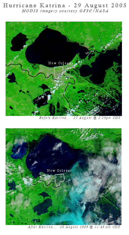
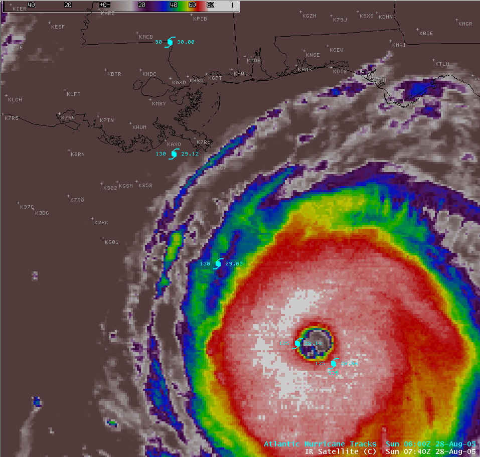
Hurricane chasing/journalism is dynamic, and I know that I certainly have no future intentions of chasing hurricanes, simply because I know that there are just too many unpredictable things that can lead to very unsafe situations. I will stick with supercell thunderstorms, simply because I understand these storms far better and their damage capabilities are far more localized than hurricanes, and that is the bottom line for me. I’m not out to photograph/videograph destruction, but rather the artistic beauty of the atmosphere. For me, the artistic beauty of hurricanes is the view from above; the high-resolution imagery taken from satellite. This is absolutely amazing to me, and I’ll continue admiring from afar. That said, I respect my hurricane chasing friends Jim Leonard and Jim Reed, especially, because time and time again, they get it done right, even if they do put their life at risk, and they share their stories and photography/videography around the world allowing ordinary citizens vulnerable to these storms to gain a true appreciation for what the atmosphere and ocean can really do.

September 2, 2005

The Humanitarian Catastrophe

Filed under: Editorial — Mike U @ 4:43 am

The Katrina Aftermath and New Orleans. This is no longer a natural disaster. This has rapidly spiralled into easily the worst humanitarian catastrophe in the history of this great country.

It’s 4:30 am, and I just finished listening to a recorded interview from Nagin, the Mayor of New Orleans himself, on the WWL radio station from NO. It is now Day 4 of this crisis and the anger and frustration from the mayor of NO has grown to a boiling point. It was the most frightening, to-the-point “slamming” of the entire governmental chain of the United States I have ever heard, regarding the complete inept in utilizing all the resources capable to SAVE LIVES. The mayor cussed. He has completely lost faith in the entire governmental chain from State to Federal.

He is right. What the hell is going on here? Cable news network reporters in the field are saying the SAME THING!! An interview of the LA Governer by Anderson Cooper had the same tone.. Where is the HELP??!? All this talk but no action, and it was Thursday… The hurricane made landfall MONDAY MORNING.

It has gotten to the point now, that the death rate among those still left out there grows exponentially with every passing hour. Hundreds, to perhaps THOUSANDS of lives that otherwise would have been SAVED had a plan been in place. It appears as if there is no ultimate plan, no one single leader to head up this plan… There are “too many cooks in the kitchen” as Mayor Nagin has said.

Obviously, the scale of this disaster has stretched resources extremely thin. It doesn’t help that we spend billions and billions and BILLIONS supporting an Iraq mission that in and of itself has many questions. What’s left for US?? US being home… The United States. Clearly, we are a nation prone to extreme national disasters. Though events like this are rare, maybe 100 or 200 year events, they happen. There is simply NOT ENOUGH THINKING OUTSIDE THE BOX in American Government. And it disturbs me.

In the words of Mayor Nagin,
“New Orleans will never be the same……………………..”

Mike

August 30, 2005

Katrina & New Orleans: Before & After

Filed under: General Weather & Forecasting — Mike U @ 5:52 pm


Here is a before and after MODIS image (courtesy of NASA) centered on the Lake Pontchetrain/New Orleans area at 250 meters resolution. The extensive flooding is quite clear as you can see.

Katrina: New Orleans’ “Big One”

Filed under: Editorial,General Weather & Forecasting — Mike U @ 9:22 am


It’s Tuesday, August 30th. I just got home from my midnight shift and after watching the reports of New Orleans’ levee breach filter in during the morning hours while at work, I just had to keep myself up when I got home to see some of the “first of light” images from New Orleans. The video I saw shown in Fox news was just utterly disturbing. Completely. If this isn’t New Orleans’ “big one”… “worst-case scenario”, then it is damn close.

Marshall Law in effect.. this is completey, and utterly incredible. Everyone must get out of New Orleans. I don’t know what to say. Water continues to fill the city.

Mike U

August 28, 2005

29 Aug 2005: Katrina Catastrophe Inevitable

Filed under: General Weather & Forecasting — Mike U @ 6:59 am

An unprecedented meteorological event is about to take place, the likes of which I have never seen while I’ve certainly been alive. It is the ultimate perfection of atmospheric violence: A tropical cyclone in an environment so perfect, you cannot script it better. It is late August and Gulf of Mexico (GOM) sea surface temperatures are around 32 degrees C, which equates to 88-90 degrees F. This is incredible ocean heat energy that is only found in very few oceanic locations around the world. Locations that can typically breed “super” cyclones. Katrina is no exception, with an incredible 910mb central pressure at the time of this writing, it is a mere 30 hours away from “ground zero” landfall precariously close to the worst possible landfall location on the United States Atlantic-basin coastn — New Orleans.

A category-5 hurricane making landfall moving north, directly into New Orleans, *WILL* create the most incredible natural disaster in United States history. Period. This *doomsday* scenario has been played out in computer model simulations, according to a well-written series in the New Orleans Times-Picayune. Upon reading this entire series and studying the graphics…. then putting the NHC forecast track of Katrina in the place of “the big one” in the story… I began to get a lump in my stomach, and I don’t even live in the area.

Katrina is certainly the perfect storm. I have NEVER seen intensification overnight like I have seen while on my midnight shift forecasting the weather for my own area of the world in western Kansas. When I got in to work it was 115mph/936mb. Upon leaving work it is now 160mph/908mb. (Yes, it has dropped 2 more MB since I began typing this blog entry!). It is phenominal, incredible, just flat out awesome Nature. It’s just a shame that a population of 1 million plus will be affected. But this scenario is most definitely inevitable as people continue to flock to the shores.

-Mike

July 27, 2005

PhotoTrip: July 25

Filed under: Photography — Mike U @ 12:44 am

Big Basin Prairie Preserve – Clark Co., KS

I decided to get up early Monday morning (7/25) and go on a sunrise photo trip down to my favorite spot in western Kansas, the Big Basin Preserve, south of Minneola. It was a wonderful sunrise with some great photo ops. The last time I was down here doing photography was in February (2/14).

The bison were out, but were a little too far away for good photos. A telephoto lens is getting higher and higher on my wishlist; it’s a fantastic setting for great photography of the bison at Big Basin. I really need to take full advantage of these opportunities. It’s a true Kansas treasure, Big Basin.

July 21, 2005

“Whatta Cauntry!”

Filed under: Editorial — Mike U @ 11:09 pm

God it’s hot on the High Plains right now. 103 degrees here in Dodge City the past two days, but it was even worse than that in Hays, where the mercury topped out at 108 and 106 the past two days. It’s late July in western Kansas, it’s something I have to deal with :)

Whew, lot went on the past week. I drove down to Table Rock Lake last friday (15th) and met up with my brother who also drove down from Overland Park… to enjoy a wonderful weekend with family. It was a very enjoyable time from just sitting back relaxing… to getting sun burned on the lake… to going to my first “Branson Show”. No, no, no.. not an Andy Williams show.. but Russian-American comedian Yakov Smirnoff. My Aunt and Uncle, who are residents of the area, are able to get into these shows at a very discounted price. The Yakov comic show was very well done. It is a more family-oriented comedy show, but the sketches certainly made us all laugh. Yakov has an incredible talent where he is able to interject a certain seriousness at times, to capture the hearts of his audience through some of phenominal stories of how he became an American.

9/11/01. Certainly a day that changed this country in many facets of life; a day that really hit Yakov at heart. Yakov started his American life in New York, then becoming citizen several years later. Without going into the details of when he and his family moved to America (go see his show!), their first impressions of this country was one of big heart and outpouring support. So, when the two planes hit World Trade Center, it most certainly affected this Russian-American artist and comedian. I say artist. One year after that fateful day in world history, 9/11/02, an incredible rememberance was observed on the grounds of what was once the twin towers. Standing tall above these grounds, and everyone below, was a several-story tall painted mural. A mural painted by an anonymous donor. Yakov painted “America’s Heart” the night of the tragedy, which would ultimately become the vision that would stand tall above Ground Zero with the message: “The human spirit is not measured by the size of the act, but by the size of the heart”. Read more here.

« Newer PostsOlder Posts »

Powered by WordPress