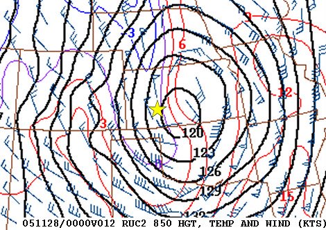
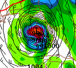
I’m finally getting around to writing about the big Great Plains blizzard early last week. It was essentially a non-event for here in Dodge City, but we really didn’t miss this winter fun but very far… for areas near I-70 in northwestern Kansas were about the southern extent of this far-reaching major blizzard. The storm lasted from roughly mid to late afternoon on Sunday the 27th and continued through the day on the 28th before winding down early on the 29th. Widespread 50 to 70mph winds existed from western Kansas through most of central Nebraska into central and eastern South Dakota. By the storm’s end, the largest snowfall amounts were in the foot to foot and a half range…mainly from north central Nebraska into south central South Dakota. This is also coincident of the strongest winds during the event…where severe blizzard conditions lasted a solid 24 hours at some locations.
A storm chaser friend of mine, Mike Hollingshead (http://www.extremeinstability.com), actually chased and documented the event. You don’t really “chase” these kind of weather events, per se… but just document the events as they unfold near your location. Much like my heavy snow chase along the Front Range in Colorado on October 10-11 a couple months ago.
 Some of the towns and cities that took it on the chin with this storm…with blizzard conditions being reported at least 12 hours or so…included Goodland, KS…North Platte, NE…Broken Bow, NE…Ainsworth, NE…O’Neill, NE…Winner, SD…Pierre, SD. This was certainly a large scale event stretching some 600 to 700 miles from northeastern Colorado into the eastern Dakotas. It was a storm that actually unpredicted…to an extent. There was a general consensus some 5 to 7 days ahead of time that there may be a winter storm of some sort…somewhere on the plains…towards the end of the Thanksgiving holiday. None of the models, however, predicted the ferocity of this event until maybe 2 days out…if that. Some of the short term models didn’t catch on to the explosive deepening of the storm until Saturday (26th) afternoon! I bolded Ainsworth, NE above because if there was one town that got about as clobbered as any in this event…it was Ainsworth. See the weather observations below.
Below are some of the awesome observations during the storm (every 3 hours through the blizzard…in coded METAR format).
Goodland, KS >>
METAR KGLD 271753Z AUTO 34023G34KT 1/4SM +SN FG OVC003 01/M01 A2934 RMK AO2 PK WND 35040/1656
METAR KGLD 272053Z AUTO 34034G40KT 1/4SM SN FG BKN003 OVC009 00/M01 A2934 RMK AO2 PK WND 34041/2025
METAR KGLD 272353Z AUTO 34040G51KT 1/4SM FZFG M01/M01 A2938 RMK AO2 PK WND 34051/2353
METAR KGLD 280253Z AUTO 33043G54KT 2SM UP BR OVC030 M01/M03 A2941 RMK AO2 PK WND 33054/0253
METAR KGLD 280553Z AUTO 33032G45KT 3/4SM BR VV014 M02/M04 A2946 RMK AO2 PK WND 34045/0546
METAR KGLD 280853Z AUTO 34036G45KT 1/2SM FZFG BKN009 OVC014 M04/M06 A2951 RMK AO2 PK WND 33052/0816
METAR KGLD 281153Z AUTO 34044G53KT 1/4SM FZFG VV003 M05/M07 A2955 RMK AO2 PK WND 34053/1152
METAR KGLD 281753Z AUTO 34042G56KT 1SM -SN BKN075 M03/M07 A2965 RMK AO2 PK WND 33056/1745
{last observation until 290253Z}
Broken Bow, NE >>
METAR KBBW 272053Z AUTO 35028G40KT 3SM -SN BR FEW013 OVC020 M01/M02 A2932 RMK AO2 PK WND 36044/2007
METAR KBBW 272353Z AUTO 35028G42KT 1/4SM FZFG VV001 M02/M02 A2933 RMK AO2 PK WND 35048/2306
METAR KBBW 280253Z AUTO 34037G52KT 1/4SM FZFG VV001 M04/M05 A2934 RMK AO2 PK WND 36054/0158
METAR KBBW 280553Z AUTO 35039G48KT 1/2SM FZFG VV001 M05/M07 A2934
METAR KBBW 280853Z AUTO 35033G44KT 1/4SM FZFG VV001 M06/M08 A2937
METAR KBBW 281153Z AUTO 34040G58KT 1/4SM FZFG VV001 M06/M07 A2934
METAR KBBW 281453Z AUTO M1/4SM FZFG VV001 M07/M08 A2942
METAR KBBW 281753Z AUTO 34040G55KT M1/4SM FZFG VV001 M07/M09 A2946 RMK AO2 PK WND 33056/1733
METAR KBBW 282053Z AUTO 33027G47KT 1/4SM FZFG VV001 M07/M09 A2952 RMK AO2 PK WND 33051/2031
METAR KBBW 282353Z AUTO 34029G47KT 1SM HZ BKN024 OVC039 M06/M08 A2960 RMK AO2 PK WND 30054/2343
METAR KBBW 290253Z AUTO 33032G41KT 1 1/2SM HZ BKN070 OVC100 M06/M10 A2968 RMK AO2 PK WND 33045/0203
METAR KBBW 290553Z AUTO 33032G43KT 1 1/4SM -SN OVC095 M07/M10 A2978 RMK AO2 PK WND 34043/0551
METAR KBBW 290853Z AUTO 33022G32KT 6SM BLSN BKN026 M06/M10 A2983 RMK AO2 PK WND 34038/0759
Ainsworth, NE >>
METAR KANW 272350Z AUTO 34027G37KT 1SM -SN BKN004 OVC008 M02/M03 A2948 RMK AO2 P0001
METAR KANW 280250Z AUTO 33033G41KT 1 1/4SM -SN BKN012 OVC017 M03/M05 A2948 RMK AO2
METAR KANW 280550Z AUTO 34035G49KT 3/4SM -SN SCT012 OVC018 M05/M07 A2947 RMK AO2
METAR KANW 280850Z AUTO 34039G47KT 1/4SM +SN OVC004 M06/M07 A2948 RMK AO2
METAR KANW 281230Z AUTO 34042G55KT M1/4SM +SN VV000 M06/M06 A2948 RMK AO2
METAR KANW 281450Z AUTO 33034G51KT M1/4SM +SN OVC001 M06/M07 A2950 RMK AO2
METAR KANW 281750Z AUTO 33043G53KT M1/4SM +SN BKN001 M07/M08 A2954 RMK AO2
METAR KANW 282050Z AUTO 33035G49KT M1/4SM +SN OVC001 M07/M08 A2956 RMK AO2
METAR KANW 282350Z AUTO 32032G44KT 1SM -SN VV007 M06/M07 A2963 RMK AO2
METAR KANW 290250Z AUTO 32029G40KT 2 1/2SM -SN CLR M06/M09 A2972 RMK AO2 VIS 1 1/2V4
Pierre, SD>>
METAR KPIR 272353Z AUTO 34023G30KT 7SM OVC013 M04/M07 A2964 RMK AO2 PK WND 33032/2303
METAR KPIR 280253Z AUTO 33024G31KT 1/2SM SN FZFG VV004 M05/M07 A2967 RMK AO2 PK WND 33033/0222
METAR KPIR 280553Z AUTO 33025G33KT 1/2SM FZFG BLSN VV003 M06/M07 A2966 RMK AO2 PK WND 33038/0535
METAR KPIR 280853Z AUTO 34034G42KT 3/4SM BLSN BR BKN006 BKN014 OVC021 M04/M06 A2962 RMK AO2 PK WND 33042/0853
METAR KPIR 281153Z AUTO 33033G45KT 1/4SM +SN FZFG VV003 M06/M07 A2965 RMK AO2 PK WND 33048/1115
METAR KPIR 281453Z AUTO 33036G45KT 1/4SM FZFG BLSN VV003 M07/M09 A2967 RMK AO2 PK WND 33052/1422
METAR KPIR 281753Z AUTO 33033G46KT 1/4SM FZFG BLSN VV011 M07/M08 A2966 RMK AO2 PK WND 33049/1704
METAR KPIR 282053Z AUTO 32033G46KT 1/2SM UP OVC040 M06/M08 A2967 RMK AO2 PK WND 32046/2049
METAR KPIR 282353Z AUTO 32031G42KT 2SM BLSN OVC085 M06/M09 A2973 RMK AO2 PK WND 32044/2259
METAR KPIR 290253Z AUTO 33030G40KT 3SM BLSN FEW030 BKN110 M07/M11 A2979 RMK AO2 PK WND 32041/0201
METAR KPIR 290553Z AUTO 32027G35KT 5SM BLSN FEW024 OVC030 M06/M10 A2984 RMK AO2 PK WND 33037/0521
What was even more unprecedented were the observations out of the automated weather station in Ainsworth, NE. They reported continuous 20-minute observations through the duration of the event amidst incredible blizzard conditions. This station actually reported “M1/4 SM” for 10 solid hours! This is interpreted as “visibility below one quarter of a mile”. In other words, likely zero or near zero. It is unusual to see an automated weather observation report M1/4… let alone for 10 straight hours… every single observation during the event. Wow. Note all the “+SN” observations. This is interpreted as “Heavy Snow”, but this is more than likely extreme blowing/drifting of snow and actual snowfall may not have been heavy at all for some times. Here are those obs: (look at those winds!!…in bold are winds >= 50kts or 58mph)
METAR KANW 281230Z AUTO 34042G55KT M1/4SM +SN VV000 M06/M06 A2948
METAR KANW 281330Z AUTO 33043G57KT M1/4SM +SN VV000 M06/M07 A2950
METAR KANW 281350Z AUTO 33040G56KT M1/4SM +SN VV000 M06/M07 A2950
METAR KANW 281410Z AUTO 33043G53KT M1/4SM +SN VV000 M06/M07 A2950
METAR KANW 281430Z AUTO 33040G52KT M1/4SM +SN VV000 M06/M07 A2950
METAR KANW 281450Z AUTO 33034G51KT M1/4SM +SN OVC001 M06/M07 A2950
METAR KANW 281510Z AUTO 33042G53KT M1/4SM +SN OVC001 M07/M08 A2950
METAR KANW 281530Z AUTO 33041G51KT M1/4SM +SN BKN001 M07/M08 A2951
METAR KANW 281550Z AUTO 33040G54KT M1/4SM +SN VV000 M07/M08 A2951
METAR KANW 281610Z AUTO 33043G53KT M1/4SM +SN VV000 M07/M08 A2953
METAR KANW 281630Z AUTO 33039G49KT M1/4SM +SN VV000 M07/M08 A2953
METAR KANW 281650Z AUTO 33036G57KT M1/4SM +SN VV000 M07/M08 A2954
METAR KANW 281710Z AUTO 33038G52KT M1/4SM +SN BKN001 M07/M08 A2954
METAR KANW 281730Z AUTO 33039G52KT M1/4SM +SN VV000 M07/M08 A2954
METAR KANW 281750Z AUTO 33043G53KT M1/4SM +SN BKN001 M07/M08 A2954
METAR KANW 281810Z AUTO 33038G54KT M1/4SM +SN BKN001 M07/M08 A2954
METAR KANW 281830Z AUTO 33040G51KT M1/4SM +SN BKN001 M07/M08 A2954
METAR KANW 281850Z AUTO 32035G46KT M1/4SM +SN OVC001 M07/M08 A2954
METAR KANW 281910Z AUTO 33037G50KT M1/4SM +SN OVC001 M07/M08 A2954
METAR KANW 281930Z AUTO 33042G56KT M1/4SM +SN BKN001 M07/M08 A2955
METAR KANW 281950Z AUTO 33038G51KT M1/4SM +SN BKN001 M07/M08 A2954
METAR KANW 282010Z AUTO 33036G49KT M1/4SM +SN BKN001 M07/M08 A2955
METAR KANW 282030Z AUTO 33034G48KT M1/4SM +SN OVC001 M07/M08 A2955
METAR KANW 282050Z AUTO 33035G49KT M1/4SM +SN OVC001 M07/M08 A2956
METAR KANW 282110Z AUTO 33037G49KT M1/4SM +SN OVC001 M06/M08 A2957
METAR KANW 282130Z AUTO 33042G52KT M1/4SM +SN OVC001 M06/M07 A2958
METAR KANW 282150Z AUTO 33039G48KT M1/4SM +SN OVC001 M06/M07 A2958
METAR KANW 282210Z AUTO 33035G45KT M1/4SM +SN OVC001 M06/M07 A2959
METAR KANW 282230Z AUTO 33035G48KT M1/4SM +SN OVC001 M06/M07 A2960
METAR KANW 282250Z AUTO 32039G47KT M1/4SM +SN VV000 M06/M07 A2960
I’ve done some research on historical blizzards since 1948 over the past couple of years, and I must say this one stacks up there as one of the true classic large-scale Plains blizzards. Mike Hollingshead was in O’Neill, NE…which is about 65 miles east of Ainsworth. He experienced some incredible conditions. You can read his account and see his images here.