
I will be chasing this Friday, as it will be my only opportunity to chase this upcoming pattern due to work. It isn’t the best setup in the world, but I do envision at least some photogenic storms given the pristine skies out there. A cold front is pushing south through central Nebraska this morning, but should slow down due to surface heating both sides of the front. Storms should form in a quasi-linear fashion along the northeast-southwest oriented front. There is a very small possibility of non-supercell type tornadoes if storm updrafts form in a southwestward propogating manner along the front in a "zipper" type fashion. The cold front must stall out, though, for this to pan out. It is not out of the question, though. Will try to play the western edge of the 55-57F dewpoints where 1700-2200 J/kg CAPE may be realized. Target: Belleville KS-Hebron NE by 21z (4pm CDT)
and do not necessarily represent those of official National Weather Service forecast products,
therefore read and enjoy at your own risk and edification!"
April 24, 2009
April 20, 2009
Chase Acct: April 16, 2009 (Southwest KS)
April 16, 2009 — Daytime lightning images near Sitka, KS
I set out from Dodge City to chase some elevated thunderstorms with the sole objective to capture some daytime lightning images. I had just arrived home from a very long road trip to Las Vegas, NV for a bowling tournament at around 7:00am. After about 3.5 hours of sleep, I woke up and noticed decent thunderstorms on radar to the southwest of Dodge City with rather prolific lightning production. I was immediately intrigued and with the activity moving closer to Dodge City, I decided to make a go at some lightning photography. I left Dodge around 12:30pm, and about 10 miles south of town, realized I had forgotten my tripod. Obviously, for the kind of images I wanted, I absolutely needed the tripod, so I went back home to retrieve it. On the way back home, I briefly visited with Robin Lorenson, Mike Phelps, and Aaron Blaser in town as they were on their way to Colorado for a late afternoon/evening storm chase. Since I had to be at work at midnight, I could not chase that far from Dodge. I decided to intercept storms moving north out of far northwest Oklahoma into Clark County, so I drove to Bucklin then south to Sitka. I reached the storms of interest just south of Sitka where I set up at a location for about 20 minutes. I did manage to capture a few cloud-to-ground flashes using the Lightning Trigger, although I overexposed one of them at f/11 since the flash was so close!


April 18, 2009
Chase Acct: April 17, 2009 (Southeast CO)
This post will be brief — I will write a more detailed account soon, but for now here are a couple images of the partially rain-wrapped tornado I observed near the Colorado-Kansas border yesterday evening at around 8:00pm CDT (7:00pm MDT). The time stamp on the first image is 8:03:45 and the second image is 8:04:33. I was photographing this tornado using a telephoto lens anywhere from 80 to 150mm focal length at roughly 1/30 of a second on the tripod. My observing location was 4.5 miles east of Coolidge about a mile or two north of Highway 50 on an unpaved road. The view was looking due west in these images toward Holly, CO. I would estimate this tornado being very close to Highway 50 somewhere not too far from Holly based on radar data at the time. Even though the primary condensation funnel never fully made it the surface, there were occasional “whisps” of condensation very close to the ground beneath the funnel… as well as at times concentrated rain curtains beneath the funnel, which gave me confidence of at least low-end tornadic circulation at ground level. More later.


April 17, 2009
Chase Forecast: 17 April 2009
"cold core" event in southeast CO/far southwest KS?
I plan to depart DDC at 1330 UTC (8:30am) for Highway 50 corridor of southeastCO somewhere between La Junta and Lamar. -23 to -25C at 500mb (wow!)with lower-mid 40s dewpoints and temperatures rising into the mid toperhaps upper 50s along/south of east-west boundary which is expectedto become more defined (supporting corridor of ~ 800 to 1000 J/kgCAPE). I think an arc of low-topped supercells may develop from west toeast along or near Highway 50 corridor as early as 17z as far west asPueblo. This could be an interesting event for southeast CO andadjacent far southwest KS.
April 9, 2009
Update #3 on 9 April 2009 “cold-core” setup forecast
Below is a visible satellite image as of 1930z. I am NOT a fan of all the mid level cloud that has developed over my target area in the zone of maximum surface vorticity at the nose of the west-northwest surge in dewpoints toward south-central KS. I’m not sure what to make of this. The nose of surface heating is displaced south of the moist axis by a fair distance, which is something I’m also not a fan of. I remember at this time of the day both on 10 November 2008 and 26 October 2006, there was NOT a large area of mid level cloud that spontaneously developed across my target with the best heating displaced south. I expected a surge in warm air northward toward Kingman-Wichita, but it is not happening. 19z obs show 70 at Alva, 71 at Medicine Lodge, and 73 at Wichita. The best warm surge is south of ICT across far north-central OK…thus am now thinking that the western limit of tornadic storms may be I-35 south of Wichita, perhaps. If I was in Kingman right now (like I probably would be at this time), I would seriously be considering heading southeast toward I-35 corridor down into Sumner County. This isn’t an easy virtual chase, and is not as "obvious" to me all of a sudden as I thought it may be like 10 November 2008 and 26 October 2006. No two "cold core" events are the same, that’s for sure, which is why it is a dangerous game to use comparisons to historical events like I do, LOL! History never repeats itself, but it does like to follow a rhythmic beat, which is why I think conceptual models and events of the past are helpful in forecasting. If this event busts, it isn’t the first time and certainly won’t be the last! That being said, it is still 20z at the time of this writing, so a lot can happen between now and 00z. In fact, I’m interested in the cyclonically rotating echoes on the DDC and ICT radars south of Pratt. There’s a 45 dewpoint in Pratt at 20z, so who knows. There could be a fluke brief tornado in Kiowa or Pratt counties since it’s so cold at 500mb.

Update #2 on 9 April 2009 “cold-core” setup forecast
Here is a 15z Surface plot with some subjective analysis of the temperature and dewpoint fields. Subjective surface vertical vorticity max is encircled. The short-term RUC and NAM suggest the surface vorticity max will strengthen and perhaps drift north through 21z…thus would expect moist advection to continue northwestward into the Wichita-Kingman area. If I was off work today, I would be driving toward Kingman right now (although I probably would have left at 11am!). Visible satellite, not shown, does reveal a very promising pristine sky in this area, so direct insolation will only aid in increasing low level lapse rates (decreasing static stability) to help spin-up the surface cyclone even more across south-central Kansas.

Update on 9 April 2009 “cold-core” setup forecast
Early this morning, it appears the setup for possible tornadoes in south-central KS still looks pretty good. In fact, I think it looks really good! I just took a look at the 09z RUC 12-hour forecast for 21z, and I am pleased to see that it matches the NAM forecast pretty good in most of the fields supporting "cold-core" surface-based severe convection. The only difference is positioning of the fields. The 00z NAM forecast was a bit farther south from previous runs, however the 09z RUC is very similar to the previous NAM runs (farther north along Highway 54 corridor). Below are a few of the 09z RUC figures I put together to illustrate:
Figure 1. 12-hour forecast of surface wind and dewpoint from the 09z run of the RUC model. The region I am most interested is encircled dotted-black. I observed tornadoes both on 26 October 2006 and 10 November 2008 in this same area, conceptually speaking in terms of the surface wind and dewpoint fields. The western nose of the dewpoint/Theta-E field at the point of maximum surface vertical vorticity is the "place to be", in my opinion, for observing (a) tornado(es) given the tremendous source of vorticity and baroclinicity a storm has to work with. There will be a southeastward extension of this rich vertical vorticity along the occluded front, so as additional storms form southeast by late afternoon/early evening, there may be several storms producing tornadoes along the surface occluded front. I feel quite confident the occluded front will be very productive! 500mb Temperatures are also shown in this figure. Note how far east the -20C isotherm extends!

Figure 2. The 12-hour RUC is generating convection in the exact area I expected it to, which leads confidence in the forecast for (a) severe storm(s) with tornado prospects. This is even farther west than I was thinking yesterday, should this be a perfect prog. Model forecast CAPE is higher than I typically see for the true "cold-core" events, with the RUC suggesting near 1000 J/kg CAPE nosing as far west as Stafford County, KS!. Usually model CAPE doesn’t capture the true surface-based instability for these events very well. This could be a signal that today could be a very productive "cold-core" day.
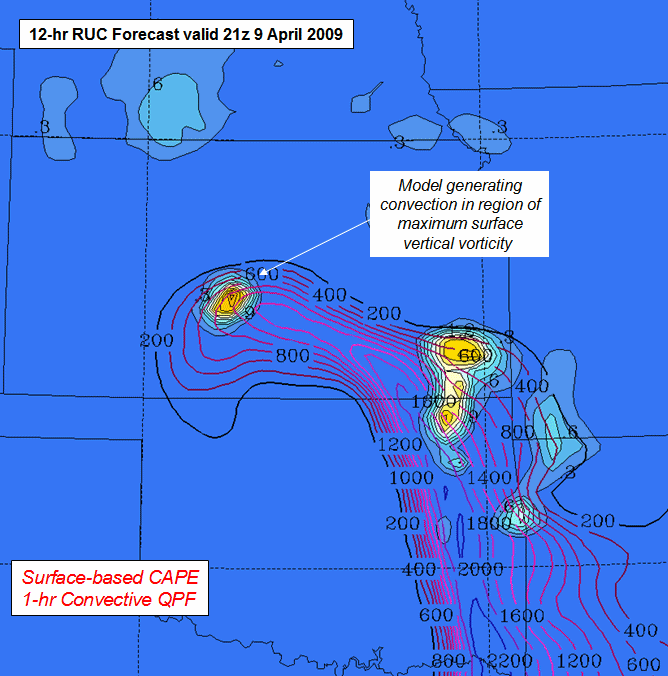
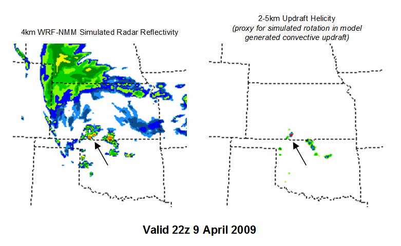
Figure 3. The 00z run of the 4km WRF-NMM is interesting. Hourly graphics of the simulated radar reflectivity show intense convection developing as far west as Coldwater-Medicine Lodge, KS at 22z… Wow! They may have to watch this closely at work (NWSFO Dodge City, KS) for our eastern counties from in the 21-22z time frame. I am scheduled to go into work at 21z!
So, the 64-thousand dollar question. Where would Mike target if he wasn’t at work this afternoon/evening?
Pratt, KS by Noon and watching the sky/visible satellite/observations/short-fuse composite very closely, with eyes set east (or east-northeast or east-southeast??) of Pratt for the 21-22z time frame!
April 8, 2009
A “cold-core” setup in South Central KS on 2009 April 9?
I am intrigued by the setup for localized tornado event in south-central Kansas tomorrow. It is shaping up to be an event with similarities to 26 October 2006. I think (a) tornado(es) may occur farther west than the current Day 2 SPC (the 1st, 06z, issuance) outlook slight risk in a small corridor where upper 40s to lower 50s dewpoints will sneak west along the Highway 54 corridor from Wichita to Kingman. Surface vorticity will be maximized in this area due to the presence of a significant middle tropospheric potential vorticity (PV) anomaly. I like to look at 400mb for wind speed fields and related PV anomalies. It is just downstream of a 400mb PV anomaly where surface cyclogenesis (in the wind field) is maximized (dZeta/dt at the surface for you meteorologists out there!). I think if surface based storms form in this zone, it will take advantage of a tremendous source of vorticity in the low levels — both vertical vorticity and horizontal streamwise vorticity. Given the substantial ageostrophic motions present in the low levels in response to a small scale jet streak like this, there will be an enhancement in ambient vertical wind shear as well as the atmosphere tries to restore itself back to geostrophic balance. Okay, that’s some heavy meteorology, but that’s what is going on in these small space/time scales. Timing is critical. Like 10 November 2008 and 26 October 2006, the event occurred in a very short time window…usually centered around 21-22z. If the current NAM model holds, then the best area at the 21-22z time frame will be along the Highway 50 corridor somewhere in a Cheney Lake-Kingman-Wichita area. Below is a conceptual model I put together for an informal presentation back in January at a local AMS High Plains chapter meeting regarding these special events. What is very interesting about my conceptual model is that the area I drew this conceptual model — south central Kansas — is exactly where I think things may unfold tomorrow (very near the yellow area on the graphic!).

Below is the 33-hour forecast from the NAM valid 21z April 9th. The graphic is of 400mb wind speed and surface wind barbs. I annotated where the 400mb PV anomaly would be based on the wind speed field…as well as where the greatest vertical vorticity would end up being as well. This all seems to point to the Wichita area or points just west at 21z:

March 24, 2009
Chase Acct: March 23, 2009 (south-central KS)
For me, this was just an “average” chase. I intercepted two supercell thunderstorms on this day after leaving Dodge City shortly after Noon. My target was Kingman, KS, but I never got there before storms started forming. I was already in “chase mode” when I reached Pratt, as the first decent storm echo on radar was developing to my south-southeast. It was really early in the day, so I just opted to let the storm come up to me on Highway 54 at Kingman. From Kingman, I followed the storm… a rather smallish LP or “dry classic” type storm… north-northeast from Cheney Lake up to Highway 50 near Burrton. This was indeed a “race chase” as this storm was trucking north-northeast at around 50 mph. This left me very little time to photograph the storm other than brief stops for a quick snap. A lot of my images of this storm were shot while driving up north on the paved road from Cheney dam to Haven. A large wall cloud formed briefly, with a beautiful rear-flank downdraft clear slot eventually taking shape to my north-northwest near Haven. These were probably my best images of the chase day.
Once the storm reached Highway 50 it became less organized and was just continuing to truck away from me so I said to hell with that storm. I then drove east to Newton, and with a new focus down along the Oklahoma border, I made a goal to get down toward the Winfield area. A fairly impressive supercell emerged out of a cluster of storms southwest of South Haven. An extrapolated path took this storm to South Haven about 15 to 20 minutes before I was expected to reach the South Haven interchange. When I first got a good glance of the structure of the storm, I realized that it was likely not going to produce any large, photogenic tornadoes, so I went into “structure mode” — basically getting far to the east of the storm to get decent supercell structure shots. The structure of the storm was pretty good while I was on Hwy 166 looking back to the west and southwest…with a very long, broad inflow band taking shape from the north through northwest feeding into the main updraft area. It just looked like there was too much rain-cooled air being re-ingested into the updraft area…however given such strong storm-relative inflow winds, rain-cooled outflow could not surge very far from the updraft area. So what ended up happening, from my observations, was that you would end up with nice looking wall clouds for a few minutes — only to evolve into crappy looking fragmented pseudo miniature shelf-cloud looking features.
The best of these wall cloud features I photographed was along Highway 166 at about 4:56pm CDT looking west from a location ~ 2 to 3 miles west of Arkansas City. Very briefly, before I had my camera in hand of course, there was what appeared to be a bulbous looking laminar appearance protruding from the wall cloud about halfway to the surface. I tried to get a photo of this, but was just a little too late. This would have been almost directly in line with Highway 166, or barely south — not too far from Ashton. Anyway, after this, the wall cloud became fragmented with outflow seemingly winning out for that feature. I continued into Ark City and then eventually north on County Road 1 about 7 or 8 miles east of Ark City. The structure was never really the same as it was back farther west…and the whole thing was just becoming a big mess — and not very photogenic. Nevertheless, I captured a few images as the storm’s core was approaching my location shortly before reaching Hwy 160 east of Winfield. Not long after this, I gave up on this storm given the yucky structure and it moving farther east toward southeast KS. I’ve never had luck photographing a storm in southeast Kansas, so I figured this storm’s structure would continue to degrade. I drove back to Winfield and got some dinner at the Mexican restaurant in town. After this, I headed south a bit to photograph backside Cumulonimbus development of storms coming up from far northern Oklahoma with only marginal success. I called it a chase right at sunset and began my trek back to Dodge City. All in all, not too bad of a chase. I’ve had much better — and much worse chases — that’s for sure.


March 22, 2009
Chase Forecast — March 23, 2009
Tomorrow is a chase day if I can get off work early. I am scheduled an "easy to get off" supernumerary day shift, and since I’m not working a forecasting shift + the fact that severe should avoid the Dodge City forecast area, I can probably take a half day off, leave at noon, and head east toward Wichita. I do plan to "join the masses" and play the conventional obvious target from Wichita, KS to the Oklahoma border. This does appear to be the best play — along the dryline and ahead of the cold front which will be moving rapidly southeast through central KS by late afternoon/early evening. Surface winds should back to about 170 or 180 degrees by late afternoon, increasing surface convergence along dryline. I like to play the thermal noses along and immediately west of the dryline…and this also appears to be setting up along the KS-OK border by late afternoon somewhere between Medicine Lodge and Harper, KS. My target is somewhere between Kingman and Harper at this point (see black circle in image below). I will have Underthemeso.com in "chase mode" by early afternoon if I do indeed get off work early. That final decision will be made in the morning while at work. At this point I’m about 80% sure I’ll get off and be able to chase.