disclaimer: "The meteorological
views/forecast
thinking expressed are those solely of the author of this blog
and do not necessarily represent those of official National Weather Service forecast products,
therefore read and enjoy at your own risk and edification!"
and do not necessarily represent those of official National Weather Service forecast products,
therefore read and enjoy at your own risk and edification!"
April 24, 2010
chase trip update 4/24 3:45pm
I’m currently sitting just south of I-40 in New Mexico to the west of
Santa Rosa. Internet connectivity is in and out, so I thought that
since I had it here along the interstate I would update the chase trip
blog. I am watching a few showers developing to my west and
northwest. As time goes on, there is more and more mass to the
showers, and hopefully in time I’ll get a few lightning strikes from
one of these. Otherwise, the landscape is great with the scattered
virga in the distant west and northwest with the Sangres in the
distance. I will follow this activity south through the late
afternoon and early evening, and am hoping the good “golden hour” New
Mexico light comes through! I will be staying in Roswell, NM tonight.
-Mike U
Chase Trip Day One (Apr 24) Morning
Departing for Chase Trip #1: First stop — New Mexico
As mentioned in the previous blog post, I will be heading to New Mexico this morning. The plan is to photograph showers/isolated thunderstorm rolling off the southern Sangre de Cristos with the emphasis on “golden hour” light/colors of landscape and convective elements in the sky. Target is Las Vegas, NM by early to mid afternoon for lunch, then following the good light, color, landscape and sky after that! Probably ending up around Santa Rosa or thereabouts by early evening.
Coming up:
Sunday is a down day and I will drive east into West Texas… staying in either Lubbock or Abilene. Monday appers to be a chase day as there are decent signals for an isolated chaseable storm at the nose of the hot air ahead of an advancing cold front along the I-20 corridor in North Texas. Tuesday and Wednesday look like down days, too, and I may do some sightseeing/landscape photography… but not sure where yet. The pattern becomes active again by Thursday.
April 23, 2010
Chase Trip Day 1 (2010 Apr 24) Forecast Update
Heading to New Mexico instead.
I decided against chasing storms in the “cold pool” of this storm. The mid level cyclone will be weakening as well as the surface circulation. There will likely be a lot of mid level moisture wrapping around near the center of the decaying system anyway. Too many negatives. That being said, there could be an interest 2-3 hour period early in the afternoon, perhaps, across eastern Kansas near what’s left of the surface circulation, but I’m still most likely not going to pursue this. Instead, I plan to leave early in the morning tomorrow and set sail for New Mexico. The reason is simple: I love New Mexico, even if there aren’t any storms. Even mountain showers rolling off the southern end of the Sangre de Cristos early in the evening can provide artistic photography opportunities in New Mexico — and this is exactly what I’m going to attempt… some “golden hour” early-mid evening sky/landscape photography somewhere just off the Sangres along or southeast of I-25. Models have been persistent in generated convective QPF amidst admittedly paltry CAPE (200-400 J/kg), but that’s okay. It’s New Mexico, and I love this state. Beats hanging around Dodge on Annual Leave, that’s for sure ![]()
Chase Trip Day 1 (2010 Apr 24) Forecast
First day of vacation appears to be a chase day… in Iowa of all places… followed by a few down days.
I am considering chasing the “cold core” setup in western Iowa on Saturday, April 24th for the first day of my early chase vacation. I will likely leave Dodge City after work this evening and stay along I-80 somewhere (Lincoln, York, etc.). Mid 50s dewpoints are expected to hang back near occluded surface low beneath mid level cold pocket aloft, and forecast CAPE of 1500+ J/kg is expected. It will likely be an early show, which is why it will be imperative for me to depart early Saturday morning from where I stage overnight. Sunday I will likely drive back to Dodge City, the way it appears now… do some last-minute chores around the house and finish full packing for a potential long period away from the house. It all depends on the weather/chasing pattern though. There will likely be at least a couple decent chase days mid to late next week as another significant storm system comes out onto the western Plains (Apr 28-29th or so).
April 22, 2010
Southwest Kansas Severe Weather 4/22/2010
Tornadoes in Southwest Kansas possible on 4/22. Interesting setup tomorrow… the NAM has begun a trend bringing the warm front farther north into western Kansas like what the GFS and the ECMWF has been showing the past couple of days. I was worried that the low stratus would keep most of western KS shrouded in a more stable airmass… limiting CAPE and potential for widespread severe this far north into southwest Kansas. Well, the 22/00z NAM has quite a bit more CAPE farther north… at the nose of the 500mb speed max… with pretty impressive cold advection at 500mb. 850mb winds will ramp up to around 40+ knots from 00z to 03z with wild low level hodographs from Dodge City south into the eastern Texas Panhandle. This is a favorable environment for late evening tornadoes. The only limiting factor for significant tornadoes will be quantity of low level moisture…. with dewpoints likely at or below 61°F. Other than that, the pattern looks fairly vulnerable to tornadic storms in the 00z to 03z time frame.
Below is an IDV four-panel of the 22/00z NAM model valid 03z April 23 (10pm Central Time the 22nd). Looking pretty darn impressive… and a long evening at work perhaps for me on overtime, as I’m on a day shift at WFO Dodge City tomorrow… so no storm chasing for me. Good luck to all the storm chasers heading out…

April 18, 2010
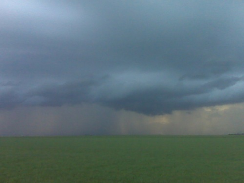
Chase Account: April 15, 2010 (West-central KS)
first chase of the season — non-severe storms, Gove County, Kansas
My first attempt at a long-winded chase account was just erased after 30+ minutes of writing, and I’m not up to re-writing it… the upshot of it was that I chased quasi-linear multicell storms, of the non-severe variety, late in the evening on Thursday, April 15th. I intercepted the storms just northwest of Quinter before heading south again on various farm roads of eastern Gove County. The best images came around 8:15pm or so…
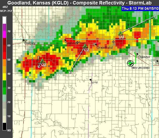
…around the time of sunset when I photographed beautiful colors with a cloud-base lowering present associated with the strong updraft (with cell “D3″ in the above radar image). After the colors waned, I headed farther south on more county roads approaching Hwy 4. The chase was pretty much over by that time as the storms had no more photographic interest due to weakening and no ambient light left. Images below! (NOTE TO SELF: next time, draft your write-up in Wordpad, not the WordPress blog post window!!! Ugh.)
This SimpleViewer gallery requires Macromedia Flash. Please open this post in your browser or get Macromedia Flash here.
This is a WPSimpleViewerGallery
This is a WPSimpleViewerGallery
Testing voice to text with blackberry
Test. I am testing my new Blackberry voice-to-text messaging application for mailing storm chasing application since I do a lot of solo storm chasing. The tornado was reported 5 to 10 minutes ago to the north-northeast of Garden City and it is heading towards Calvista. Again, this is just a test. Bye.
[ Transcribed by MyCaption ]
April 15, 2010
Colorful storm at sunset
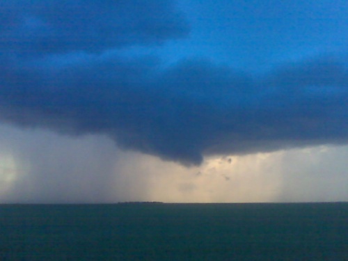
Camera phone doesn’t do it justice at all. Photos from my Nikon will b far superior obviously