It is Tuesday morning, day 7 of the trip. The next three days (including today) appear to be fairly active severe weather days with better moisture and better wind shear in play. After Thursday, it looks like the good chasing will come to an end as a large high pressure builds over much of the northern and central Great Plains. Today, Vince and I will head north from Belle Fourche to southwestern South Dakota. Water vapor loop shows a vigorous storm system moving from west to east, which will be timed nicely for the western half of North Dakota. This looks like an excellent environment for a quality supercell thunderstorm. It also looks like we’ll be in much better cellular internet data areas according to the Alltel map. We’ll have the live ‘chase mode’ map going later on today.
and do not necessarily represent those of official National Weather Service forecast products,
therefore read and enjoy at your own risk and edification!"
June 24, 2008
June Chase Trip 2008: Day 6 Summary – Southeast Montana Lightning
June 23, 2008 — Daytime lightning & stormy sunset colors from Broadus to Alzada, MT
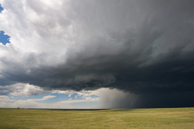
We began the day in Glendive, MT and decided on a target downstream of the Big Horn Mountains, as we liked the mid-50s dewpoints hanging around near the stalled out front near the WY-MT border area. Another possible target was quite a bit farther east into North Dakota, but we didn’t feel like going all that way as we could have ended up on the opposite side of the state, only to drive back west again the next day. We were hoping for a good storm or two to develop near Sheridan or the WY-MT border and track along the border area. The drive from Miles City to Broadus took us through Volborg — a post-office "town" with a population of 2. There is a small General Store there that also operates as the Post Office, which is run by Dick Stanley and his wife. The front of the General Store states a population of 5, which represented several more of the Stanley family, but they have since moved on to other portions of the Southeast Montana/Northeast Wyoming region. We had an absolutely lovely visit with Mr. Stanley, and his little General Store out in the middle of nowhere on highway 59 to the north-northwest of Broadus. Most importantly for our purposes, he had internet access there in his store, and he was more than welcome to allow us to look at some meteorological data as we conversed about different things such as being a (precipitation only) Co-op observer for the National Weather Service in Billings. Below you will find a photo of Mr. Stanley — who represents one-half the current population of Volborg.
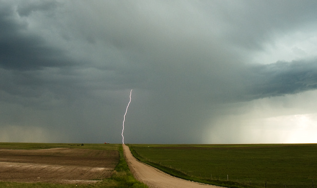
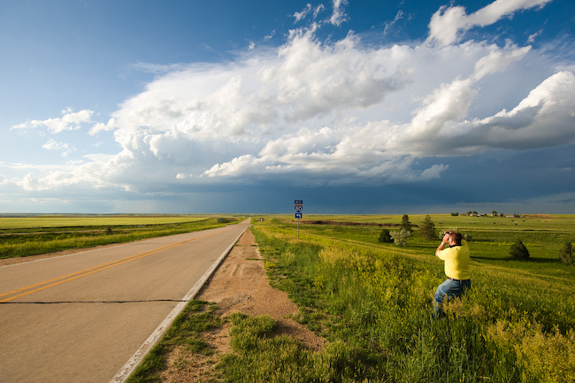
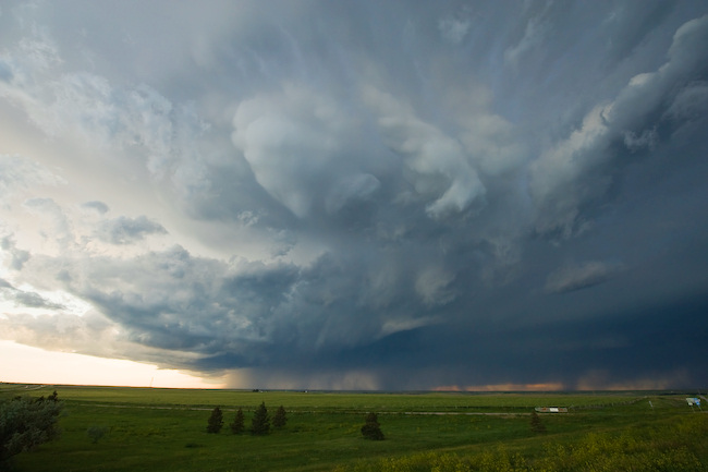
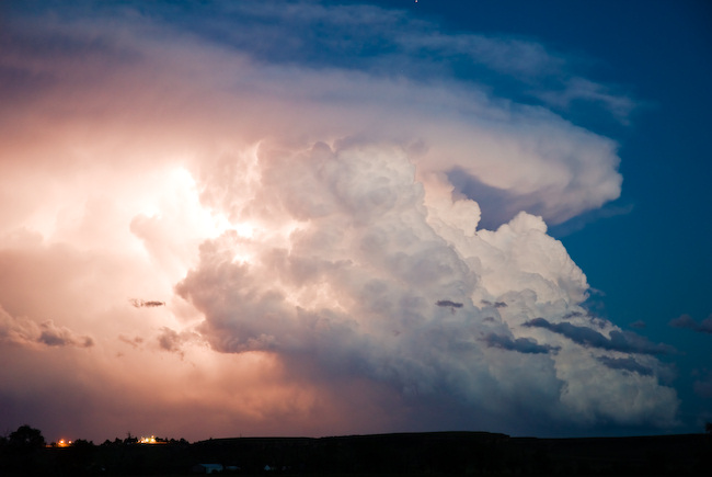
After that fun visit, we continued on to Broadus, and we visited the library to get some data (talk about old-school!) since we had no cell data service in Southeast Montana. We monitored three areas of interest: 1) A line of surface-based cumulus to our north which extended northwest to southeast…through about Volborg, 2) a severe storm that had developed over the Big Snowy Mountains south of Lewistown (this is a hot-spot for storm initiation, by the way), and 3) storms organizing to our west-southwest over the northern portion of the Big Horns. We optioned for #3, and we decided to take a scenic unpaved route southwest out of Broadus that parallels the Powder River — Moorhead Rd. We ultimately only went about 10 miles down that road before turning back around to Broadus… but the scenery was wonderful and would make for an awesome drive when more time allows. Storms to our west and southwest were struggling mightily with a lack of decent structure both on radar (ThreatNet) and visually. We decided to head west to intercept the storm mentioned above as option #2. We only got about 10 miles west of Broadus when we realized the lightning to our west-southwest was rather frequent, sharp, and photogenic. So we stopped. And it’s a good thing we did — as the lightning was beautiful with excellent visibility. We stayed here for a little while then back-tracked again to Broadus to follow this development southeast on Hwy 212. We stopped again several more times along the way to Belle Fourche, where we stayed the night. Our last sunset stop near the MT-WY state line southeast of Alzada was very photogenic with very awesome, warm colors from the setting sun. Lightning in the distance amidst the orange hues of the late evening sunset made for nice photography — and this is the very reason why we love chasing up here — as seemingly innocuous storms can be extremely photogenic with the wide-open spaces and incredible visibility/light. These photography opportunities really made the day. Some images are below — including one fine image (the 4th one below) by Vince of me silhouetted against the bright backdrop towards the sun, while photographing lightning with my camera gear… which includes the lightning that I was photographing. It was handheld with a shutter speed of 1/320 of a second. I don’t know how he got that shot!! But I love it. In fact, it was 1 of 2 lightning images he just so happened to capture yesterday hand-held with a fast (for lightning) shutter speed. Of course, I was shooting with the Lightning Trigger on my D200, but Vince showed that last night, you can take daytime lightning photos without it ![]()


(c) Vince Miller


June 23, 2008
June Chase Trip 2008: Day 6 — Southeast MT/Northeas WY
Update 12:20pm MDT:
We are in Miles City again, heading to the south. there is ~1500 J/kg of CAPE across far northeastern Wyoming along the Big Horn Mountains and points east. The live chase mode will cease to update as we once again head into internet no-man’s land. More later!
June Chase Trip 2008: Day 5 Summary – Brockway, MT storm
Sunday, June 22 was somewhat of a frustrating day in the sense that we mis-forecast our target of southeast Montana — nothing formed in that area at all… not even any cumulus. We left around midday from Buffalo, WY and set forth for the Biddle to Broadus, MT area. By mid-afternoon it became quite apparent that it would take an act of God to get any storms in this area, given the close proxmity of the short wave ridge, the amount of cirrus overhead limiting heating, and the best jet energy going to the north. At Broadus, we headed north Miles City when we saw some storms developing on ThreatNet (on Vince’s laptop) north of Miles City. We reached Miles City in the mid-evening hours and tracked northeast on I-94, witnessing a distant storm our north. Initially, it looked quite promising with a lot of good inflow cumulus and flanking line towers feeding into the main updraft region. We stopped north of Terry for only storm photography of the day as this briefly supercellular storm was beginning to die a nasty death. Once this happened, we ultimately decided to just head into Glendive, MT for the night — and hope that additional stuff would form around us for some lightning opportunities. This really didn’t happen either, except to our distant east.
Today — Monday June 23rd: Early morning data suggests two potential targets along a northeast to southwest axis. One would be along the old convergence axis across the northwest SD-southwest ND border region and the other would be post frontal northeasterly upslope against the Big Horns region (targeting Northeast WY). We’ll continue forecasting/deliberation on this final decision.


June 22, 2008
June Chase Trip 2008: Day 5 — In the field update
6:05pm MDT:
We are currently in Miles City, and we are about to intercept a newly developed supercell storm to our north. It is moving east in the general direction of Glendive. We have just fueled up here in Miles City and about to begin the chase. More later after a successful chase we hope! We are using Vince’s computer since we thought We’d be in cell data void areas for most of the chase, but now that we are on the Interstate, we have data (for the time being). Thus, we are not beaconing our position this evening.
June Chase Trip 2008: Day 4 Summary – Down day
June 21, 2008 – Down day, drive from Lusk to Buffalo, WY
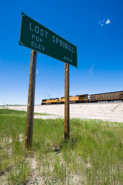
Day 4 was a down day as an upper level ridge was building across the northern Rockies. We decided to take a leisurely drive up to Buffalo, WY via highway 20 and I-25 from Lusk. We were hoping an isolated picturesque storm would form off the Big Horn mountains, but it wasn’t to be. We stopped a couple times along the way after leaving Lusk to see a view of the old abandoned towns that Vince was interested in, such as Lost Springs, Manville, and Keeline along Highway 18. The Lost Springs population according to the highway sign was One. An updated sign in town said Three. Anyway, it was interesting to see. The Union Pacific rail line runs through there along Highway 18, and there were no less than 3 full coal trains that traveled east, supposedly coming from the Wright or Verse areas. We got to Buffalo in the early evening with a convective-free sky. We stayed at the Big Horn Motel again on Main Street in downtown. The motel owner also owns a small ice cream parlor/mini-golf establishment a few blocks down a walking path along the Clear Creek, so we checked that out. The little parlor was busy with a big line as they had some outdoor "family in the park" outing right there at this small park next to the parlor.
Today, Sunday June 22, we will head east-northeast from here, likely into far southeastern Montana. A resumption of storms is expected today. We will probably use Vince’s laptop on the chase today since southeast Montana is a giant cell data void area. Vince has the satellite-based Baron Threatnet on his laptop so we can continue to monitor radar and the like. Thus, there will likely be no live-chase mode updates on the website today.
June 21, 2008
June Chase Trip 2008: Day 3 Summary (Cheyenne, WY)
June 20, 2008 — Briefly severe storm; Chugwater to Cheyenne, WY
This was a rather short chase. Vince and I intercepted a storm that had some supercell characteristics early on as it was west of Chugwater moving south-southeast toward Cheyenne. We finally got good visual of the storm north of Cheyenne by just a few miles. We sat at a location just west of I-25 and watched a new impressive updraft surge occur just north of us with some weak cloud base rotation. We were also watching some small Cb growth to our south. As we drove south back into Cheyenne, our northern storm weakened rather substantially. After a quick gas fill-up, we reconsidered our options. All the storms at around 3:45pm mountain time looked rather uninspiring both visually and on radar. We decided not to head any further south and to pseudo blow off the rest of the chase, and hope that something else of substance could form farther north across eastern Wyoming. While there were a few small, marginally severe storms developing east of Lusk (which was where we were heading), we decided to just bag it and go on in to Lusk and enjoy a nice relaxing pizza dinner at this awesome pizza house here in downtown Lusk. We are staying at this same motel we stayed at last year (Town House Motel) — it’s small, but quite clean and roomy. Below are a few photos from our one and only stopping location to document north of Cheyenne:

June 20, 2008
June Chase Trip 2008: Day 3 Forecast, June 20
We are on the road west out of Sidney, NE at 1pm Mountain Time heading west… but not all that far probably. We are anticipating more chaseable storms off the Laramie Mountains today. In fact, there are already a few storms going up in the early afternoon sun out there…which will eventually spread onto the adjacent plains later in the afternoon and this evening. Today may be a carbon-copy of yesterday with high-based, yet photogenic storms (marginal supercells). After today, attention finally shifts to the north, but Saturday will be a down day. We will probably head up toward Rapid City/Spearfish/Belle Fourche tomorrow to stage for Sunday’s expected severe. More later!
June Chase Trip 2008: Day 2 Summary (CO-NE Border)
June 19, 2008 — Picturesque Severe Storms; Weld County, CO to near Sidney, NE
Vince and I started the day in Colby, KS with a target of the southwestern Nebraska Panhandle in mind. We anticipated storms forming off the Laramie mountains west and northwest of Cheyenne. This indeed happened as forecast. The first storm we chased was one which developed just north-northwest of Fort Collins. This was initially a storm with supercell characteristics on radar as we were driving toward it… another one of those "left moving" supercells. The main storm updraft kept moving/developing to the northeast against the west-northwesterly flow aloft. We intercepted this storm in far northeastern Weld County only a few miles south of the Nebraska border. The contrast and colors were pretty good, and I managed to capture a couple cloud-to-ground lightning flashes to the west. Eventually, this storm weakened and became a bit more "messy" on radar (and visually). We continued east for quite some distance along County Route 78. One thing that was striking was the gigantic wind farm that extends west to east along the crest of the Cheyenne Ridge in this area (Peetz Wind Power). Once we reached Hwy 113 (which turns to Hwy 19 in Nebraska), we continued north to Lorenzo and monitored a fairly well structured, but very small updraft base to the west. It was eventually severe thunderstorm-warned based on one report of Golfball size hail.
We continued on into Sidney and east on I-80, reaching exit 69 where we watched our Lorenzo storm die a rapid and ugly death before our eyes. However, new severe storms were rapidly developing off to the north through northwest. We sat atop the overpass at exit 69 for quite awhile monitoring both storms. Eventually, the southeast moving marginal supercell (taking aim on Sidney) came into view. Vince captured some pretty good time lapse since we sat at this location for quite awhile. As the storm became west-northwest of us, the light got a lot better and we could see structure quite a bit better. Not the best storm structure by any stretch, but the color contrast was clean and very photographically-friendly. Some large bulbous shaped mammatus developed which was great to capture on the 14mm wide angle lens.
We finally called it a chase and went back west to Sidney for the night… but beforehand, we stopped one last time to photograph the beautiful distant Cb to the southeast (long exposure on the tripod). Some interesting lightning was also captured within the updraft by both Vince and me.
Today, June 20th, Vince and I will probably be chasing in the same general region — maybe a bit farther south into Colorado. Then it appears Saturday may be a down day/drive day… as we like the looks of Sunday’s prospects wayyy up north near the MT-Canada border. More details on that later.
Below are a few of the images of the 211 frames I captured yesterday:
June 19, 2008
June Chase Trip 2008: Day 2 Forecast, June 19
Currently on the road, entering Colorado from Kansas on I-70. We debated whether to target the Raton Mesa to our southwest or southeastern Wyoming. Both areas look favorable for severe storms (The Raton Mesa area probably moreso), however given the fact that we plan on staying north for the majority of this trip, we’ll hedge north. It doesn’t look that much more spectacular down there anyway — in fact storms may tend to be more HP-type in nature due to a bit weaker upper level flow down there. We are planning to stair-step our way northwest toward the CO-NE-WY tri-border area. There’s already a weak storm developing along the northern end of the Laramie Range at midday. There’s decent sunshine/heating occurring in the target area.