High Plains Drifter


disclaimer:  "The meteorological views/forecast thinking expressed are those solely of the author of this blog
and do not necessarily represent those of official National Weather Service forecast products,
therefore read and enjoy at your own risk and edification!"

June 23, 2007

Late-June Chase Trip (Day 2): NE Panhandle area

Filed under: Chase Accounts,Chase Trip 2007,Storm Chasing — Mike U @ 10:19 am

Summary:

Chadron, NE slow-moving high-based supercell!

What an excellent photography day… probably my best storm photography day of the year.   Vince and I targetted the area over the northwestern corner of the Nebraska panhandle near Harrison.  We were worried about the low dewpoints out this far west… but also realized that quality moisture was just east of our target area…and on increasing southeasterly surface winds by late afternoon/early evening…the western edge of this moisture would make it towards our target.  On our drive west we noticed storms firing over the Black Hills area which were rather disorganized on radar and not moving much.  Once we got to Pine Ridge and had a quick lunch, we dropped south as some congested cumulus southeast of us caught our eye…which was a little bit closer to the deep moisture.  We eventually made it over towards Chadron and then just west of there where we drive around this small lake near Whitney.  The area of cumulus to our east finally developed into a storm about 30 miles east of us, so after driving around the small lake we back-peddled towards Chadron and continued east of town about 4 or 5 miles.  We had a great backside view of a small storm that indicated severe hail potential on radar and eventually split.  After the storm split, both members of the split appeared less interesting visually.  One thing we noticed at our stopping location was that our winds increased fairly substantially out of the southeast.  This was very interesting and we thought for a moment it could possibly be outflow from that storm… but we were too far away and the storm was too small for this to be outflow… plus it was still quite warm.

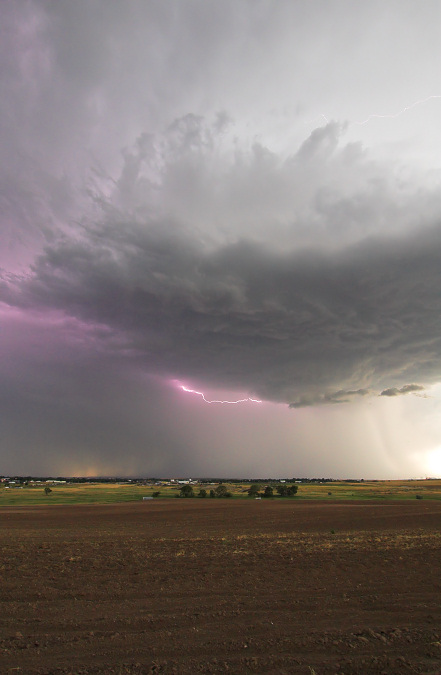
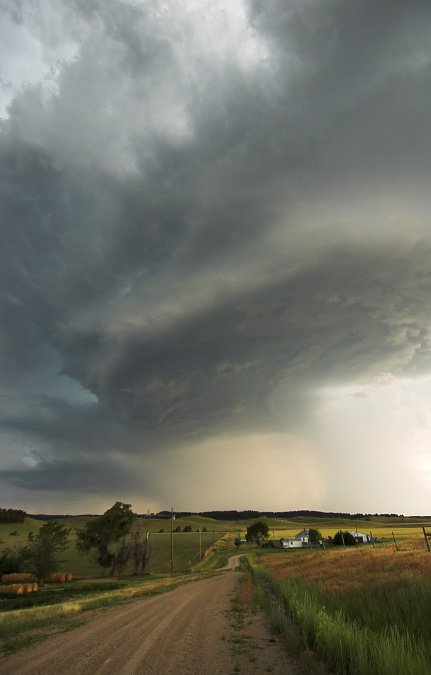
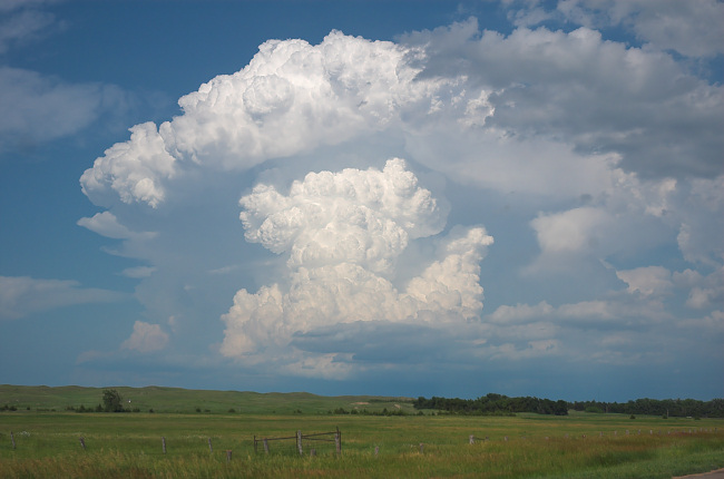
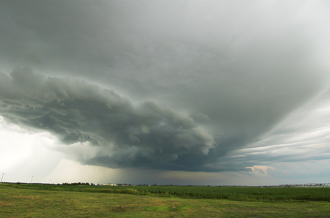
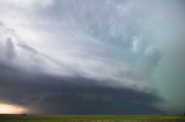
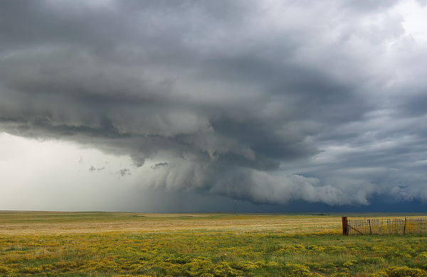
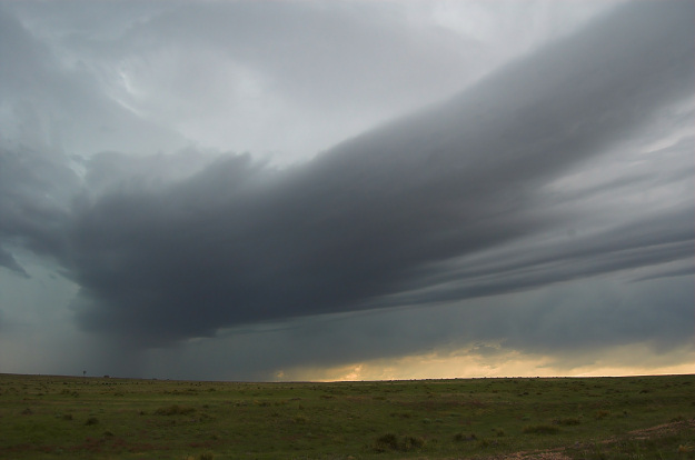
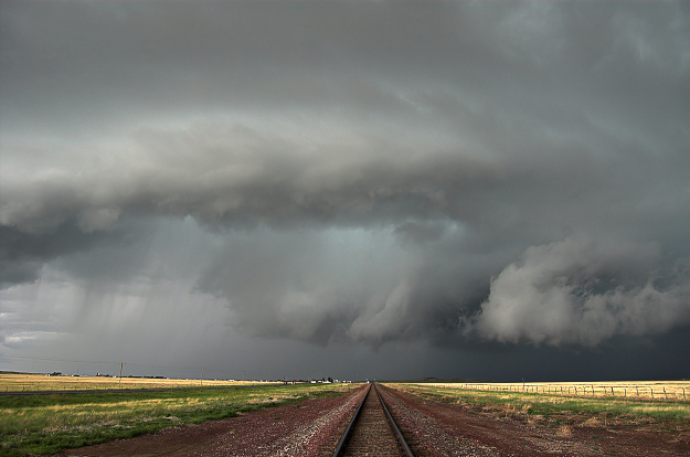
Looking back to the west where there was already some high-based disorganized convection…we became more interested with this newly-found strong southeast wind.  Sure enough, a storm west of Chadron began to reveal a more interesting dark base and we headed back west a bit towards Chadron.  Just before getting into town, we went north on a road that lead up a hill overlooking Chadron.  What a view!  I remember watching a storm several years ago from this very same hilltop in fact.  The next one hour was just fantastic!  We watched the storm develop right in front of our eyes to our west overlooking Chadron… developing into very organized high-based structure.  At least two formidable rain-foots were highly visible and very impressive off to the west.  In fact, the Chadron Airport measured a wind gust of 60 mph right near where this rain-foot was. 

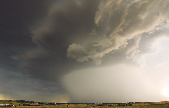
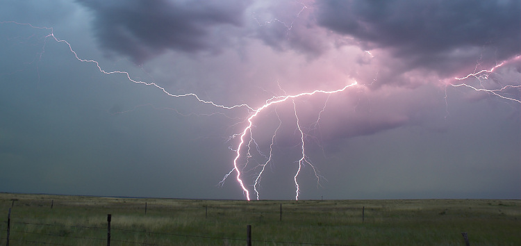
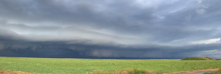
Mammatus was also taking on nice structure to our northeast spreading out from the storm.  The sound of distant continuous grumbling was just great!  The color contrast in the sky was just awesome.  Vince was shooting time-lapse video of the whole thing… a solid 55 minutes from our one location on the hill east of town.  We headed east finally as the slow moving storm was getting a bit too close, so we continued on east to stay far enough ahead to get the good updraft structure.  Circular updraft structure revealed the mesocyclone rotation within the storm.  We even had some high-based wall clouds develop with really interesting rotation at times. 

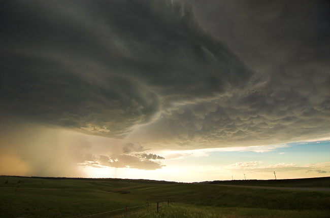
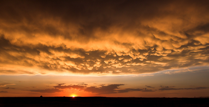
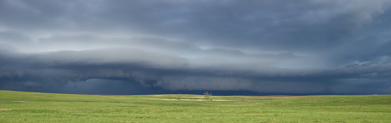
Finally at sunset, we went south from Hay Springs a few miles as mammatus was beginning to glow beautiful orange and gold in the direction of the setting sun.  We were at this stopping location for about 1hr and 10 minutes south of Hay Springs as Vince once again shot about an hour of time-lapse video of the sunset with the incredible mammatus…. adjacent a field of waving wheat.  That whole couple of hours was just high-quality photography all-around… and the slow movement of the storm allowed Vince to get some really long time lapse.  A very fun and rewarding day and very near our target area… so it was nice to see our chase forecast verify nicely.  5 photos follow:

June 22, 2007

Late-June Chase Trip (Day 2): NE Panhandle area

Filed under: Chase Accounts,Chase Trip 2007,Storm Chasing — Mike U @ 12:22 pm

Vince and I have left Winner, SD and are heading west in the general direction of Harrison, NE.  We think there will be a halfway decent upslope play today as winds at the surface become increasingly upslope by early evening… drawing low level moisture back northwest a bit.  Deep layer shear of 35 knots or so should be enough to sustain supercell structure should severe storms develop.  Will go into virtual chase mode sometime early-mid afternoon as we get closer to target. 

Outlook:  We have decided not to chase Canada Saturday… it is going to be too far north into Canada, like 150 to 200 miles north of the border… and while it looks pretty good for severe weather in that area… it’s just too far away… then we’d have to come right back south the next day.  That’s a LOT of driving.  Thus, tomorrow we will consider being a down day and head up into Northeast Wyoming for some sightseeing, see Devil’s Tower and do some landscape photography perhaps…  Sunday shows some potential in North Dakota.. perhaps along I-94 between Bismark and Dickinson.  Stay tuned!

Late-June Chase Trip (Day 1): Northwest NEB/SD Border area

Filed under: Chase Accounts,Chase Trip 2007,Storm Chasing — Mike U @ 8:17 am

Chase Summary:

Vince and I arrived  in eastern Cherry County, NE by mid-afternoon to very promising conditions for supercells… strong southeast winds, warm temperatures well into the 80s and dewpoints around 65-66 degrees.  The mid level winds were also sufficient around 30-35 knots or so for deep layer bulk shear values around 45-50 knots or so.  We took a very scenic one-lane paved road northwest towards the Merriman Reservoir southwest of Valentine where we awaited convective initiation.  Data and observations were suggesting initiation was imminent just to our northeast back near Valentine, so we opted to head into town where we re-fueled and began the chase.  We realized we needed to head southeast on US-20 (instead of due east out of Valentine) with incredible convection off to our due east.  This storm exploded right in front of our eyes about 25-30 miles east of us.  We arrived on-scene to a well-developed dark base wth lowerings off to our north-northeast from near Long Pine.  Rotation was definitely evident, but somewhat broad at cloud base.  Rear-flank downdraft clear slots would develop and fill in, redevelop and fill back in…cycling new circulations quite often.  This would be the story with this storm… there just wasn’t quite enough low level wind shear to get the job done it appeared, but boy it was close.  We came to a stopping location again a few miles up the road just outside of Bassett where we were really close to the back edge of the old occluded portion of the storm with high contents of cyclonic shear.  Cloud rotation would be strongest, and in more than one spot on the cylonic shear side of the rear-flank downdraft/occlusion downdraft area.  I thought there was indeed a potential for a brief tornado from one of these old mesos if it just stretched vorticity enough.  We saw several small funnels from this intense area of cyclonic shear on the backside.  Our surface winds were fun to observe… out of the northwest… quite warm too… and extremely gusty/variable in speed.  For a brief moment, we had wind speeds around 40-50 mph from the northwest… that were warm… only followed by dead-calm winds about a minute later!!  This told me that it was trying really hard at the surface to tighten a circulation to potentially tornado scale.  Again… it was close, but no cigar there just outside of Bassett.  We continued south on Hwy 183 about 8 mile south of Bassett where we headed east again to get closer to the updraft region and old occluded backside again.  Once again, we had very interesting attempts at tornadogenesis from an old circulation… the cyclonic shear side was just rich with vorticity and it was just fascinating watching scud fragments rotating and rising to the small occluded base becoming a rapidly roating entity almost to the point of tornadogenesis.  By this time, RFD was cooler as more rain cooled air was being ingested, and we began to become more disinterested with the storm… plus the fact it was moving away from us in a very poor section of road network.  We bailed and headed back to Bassett where we re-evaluated the situation… we thought about chasing the big complex west of us with all sorts of mesocyclone indications on radar back over the area where we staged earlier in the afternoon (Merriman Reservoir).  It was getting to be 8:30pm, however, and things were becoming more of a mess with MCS taking shape.  We settled for lightning photography (Vince with video) a few miles north of Bassett on Highway 7…then called it a chase and drove through the incredible rain and extremely bright lightning on our way to Winner, SD for the night.  What a fun chase for our first day!


June 21, 2007

Late-June Chase Trip (Day 1): Northwest NEB/SD Border area

Filed under: Chase Forecasts/Outlooks,Chase Trip 2007,Storm Chasing — Mike U @ 11:38 am

Forecast:

Vince and I have left Kearney, NE and are targetting an area near Merriman, NE to Pine Ridge, SD… near the SD/NE border.  A subtle upper level jet streak will be interacting with greater than 3000 J/kg CAPE in this area where surface wind convergence will be maximized.  Mid 60s dewpoints in this area is very promising, regardless the time of year… we should be in Merriman area by 4pm CDT.  I’ve got the website on chase mode, but in the Nebraska Sand Hills — in the middle of nowhere — cell coverage will be sporadic, so expect in-frequent updates… I’ve never chased in this area with my Alltel card before..

June 20, 2007

Late-June Chase Trip (Day 0): Departure and Plans

Filed under: Storm Chasing — Mike U @ 7:59 pm

June 20 (Day 0) 

It is about 8pm and my chase partner for the next 10 days or so, Vince Miller, will be arriving here in Dodge City in about an hour.  We’ve been discussing on the phone our tentative game plan for the next couple of days.  Tomorrow, June 21st, looks like a pretty good severe weather day across South Dakota and Northeast Nebraska.  It is unclear our exact target yet, but anywhere from Central SD to far NW Iowa looks interesting… my gut says farther west into SD, though, with moist easterly surface winds over much of the state ahead of a small jet streak/shortwave trough.  Then, Friday, we plan on blowing off Iowa and heading northwest towards North Dakota… more or less a travel day to get into position for Saturday which looks like a potentially good day in far southern Saskatchewan in Canada.  There could be isolated picturesque storms in western ND on Friday 22nd.  Sunday the 24th could also be in North Dakota as the upper trough will be slow-moving.  Going into early next week…still a lot of uncertainty and we will cross that bridge when we get there!  We are driving from Dodge City to Kearney, Nebraska this evening when Vince gets here…staging for tomorrow’s chase.

Storm Chase June 19: Southwest KS HP Supercell!

Filed under: Chase Accounts,Storm Chasing — Mike U @ 5:01 am

Wow, what awesome structure!  This was a complete impromptu chase, as I am at the tail-end of midnight shifts and didn’t wake up until 1:30pm.  I was actually awaken by a colleague at work calling to alert me of a storm I might be interested in chasing… since I *could* chase until late in the evening given the close proximity to Dodge City.  After looking at just a few things, I got a quick bite to eat, fueled up the car and took off north towards Wakeeney where a supercell was already in progress.  By the time I got to Wakeeney, the meso with this storm was moving south-southwest towards the Quinter-Park, KS area.   This storm was becoming increasingly undercut by cool outflow as I stayed ahead of it south of Park.  I drove about 9 miles south on an unpaved road then had to go west to Gove to find paved roads again with heavy precipitation coming too close to me.  Another storm to the immediate south was exploding to the southeast of me in southeastern Gove County.

I continued south from Gove on K-23 with strong northeast outflow winds buffeting me.  The new interest was indeed this southernmost storm now to my southeast…and it was showing supercell characteristics on radar with mesocyclones indicated.  I continued all the way south to Dighton when I headed east a couple miles before continuing south to stay ahead of what was now a very impressive HP supercell!  I went south on the Alamota unpaved road (it was well-grated), but I didn’t want to venture too far away from paved routes.  I knew though that if I stayed ahead of the precip core to its south… I’d be fine as no other storms were now developing ahead of this mature supercell.  I stopped briefly several times to capture some images of this storm.  Lightning was incredible with all sorts of in cloud, cloud-cloud, and cloud-ground lightning.  The sound of continuous grumbling in the upper reaches of the storm was incredible!  I eventually came to another well-grated east-west unpaved road and went east into extreme northwestern Hodgeman County where I was now watching incredible structure with that aquamarine-green scary color to my northwest.  Inflow winds at this location were 40-50 mph from the south-southeast!!  Wow.  Unfortunately with HP supercells, getting a visual of any tornado is next to impossible even if there is one.  The thing with this storm was that the roation was somewhat broad… but very intense at that.

Eventually, the tiered updraft structure became very photogenic.  What a treat!  I continued south…stopping every few minutes to get more photos of the structure…eventually reaching K-156 between Kalvesta and Jetmore.  I decided to head back west then south on more unpaved roads.  The storm was in a state of transition now and the structure wasn’t as good as it was about a half hour prior.  The storm however was still incredible with lightning frequency very high.  I eventually made it into extreme southwestern Hodgeman County to the southeast of Kalvesta about 6 miles or so…when the structure was taking on fantastic appearance again…with multiple tiers of rounded banding.  Awesome!!  I took quite a bit of photos with my new 12-24mm ultra-wide angle Nikon lens.  Eventually, I made it south to Howell on US-50 and called it a chase and headed back home… which was a whopping 6 miles away!  How convenient.  This was probably the best HP supercell structure I’ve seen in several years chasing… probably a "top-5" HP supercell storm in terms of ferocity and structure.  Below are a couple of photos:

HP Supercell structure looking west about 15 miles south of Alamota, KS at around 6:10pm CDT:

HP Supercell structure looking west-northwest near Kalvesta, KS at around 7:10pm CDT:

June 13, 2007

Storm Chase June 12: Colorado Structure

Filed under: Chase Accounts,Storm Chasing — Mike U @ 12:04 pm

June 5, 2007

Storm Chase June 4: New Mexico Again!

Filed under: Chase Accounts,Storm Chasing — Mike U @ 2:00 am

June 4th was the last chase day of a 3-day short trip to New Mexico before I set off for Nevada for my long-awaited bowling trip.  I once again began the day in Clayton (at the Days Inn this time) with a couple of targets in mind.  My main area of interest was actually near the I-25 corridor from Raton to Springer to Las Vegas where it appeared the best juxtaposition of deep layer shear and instability would exist.  Another area that kind of caught my eye was in the TX Panhandle, however low level winds were weak with really not much help from any terrain (other than Caprock escarpment).  I knew for sure there would be storms in my primary target area and was more unsure about the TX Panhandle area, thus I decided on heading west.

I left Clayton around 10:30am MDT and drove towards Raton on Hwy 64.  I reached Clayton to find a bunch of disorganized storms with little interest.  After filing up gas and considering my options, I finally decided to head south on I-25 from Raton to get ahead of a storm that had indications of marginally severe hail to the southwest of Raton.  This was around 12:30pm.  I pulled off briefly at an interchange to observe and take a photo of this storm, but it was really of little interest.  Soon, however, another storm west of this one was looking better on radar, and visually I could see a rain free base off in the distant west.  I continued south to the Cimarron exit.  Between 1:15 and 1:30pm, this storm was looking quite interesting to my northwest as I was traveling slowly west on state Hwy 58.  This is the first time I’ve chased west of I-25!  Two distinct updraft bases consolidated to form one large dominant updraft… a good sign for sustained future storm strength.  I was in a perfect position between Maxwell and Springer just west of I-25 with this new storm moving southeast towards me.  I shot photos through about 2:00pm until the storm was approaching too close and I headed back to I-25 to Springer.  The storm was well-developed now both visually and on radar with a very dark, large rain-free base and a nebulous lowering… with the Sangre de Cristo mountains as a backdrop!  The photography was just fantastic.  The storm was at its greatest intensity, with radar-indicated mesocyclone, when I was observing it to the west-northwest from a few miles west of Springer shortly before 2:30pm MDT.  The structure of the supercell was very clean with great contrast, a beautiful forward-flank precipitation core well-separated from the best updraft region and the mountains in the background — certainly my best supercell photography opportunity for me so far in 2007.  The storm continued southeast and I had to stay out ahead of it, so I dropped south a few more miles.  When I pulled off again, the storm structure was not looking nearly as good anymore, and I had a decision to make — whether to keep following this activity or to break off and head back east in the general direction of back home.  I basically achieved what I hoped to on this chase, so I was definitely content on just heading back home.  Back to Clayton it was.

When I got back to Clayton, I grabbed a quick bite to eat and refueled.  I noticed new storms forming to my north on radar and visually.  It would be tough to not chase this since this was basically moving towards the general direction of Clayton.  I drove back northwest from Clayton on Hwy 64 a few miles and noticed a brilliant rainbow on the backside of a weak storm that just recently glanced Clayton.  I stopped along Hwy 64 for numerous photos of this amazing sight.  The rainbow was fairly low on the horizon but the backside of the storm was quite photogenic.  This was pretty much icing on the cake!  A small LP storm to my north began to look more interesting so I headed north from Mt. Dora on a county road to photograph this little storm… again very picturesque.  I then continued east to follow this small storm before it began to dissipate.  Finally, before sunset, another storm farther east was somewhat photogenic as I approached Boise City and this would pretty much conclude my chase.  I had some dinner here in Boise City before I began my trek back home to Dodge City.  This was definitely one of my favorite New Mexico chases!!

Supercell storm structure west of Springer, NM with Sangre de Cristo mountains in the background:

Dissipating storm with rainbow looking east towards Clayton, NM:

June 4, 2007

Storm Chase June 3: NM/Western OK Panhandle

Filed under: Chase Accounts,Storm Chasing — Mike U @ 8:42 am

This was a chase day where two key "decision point" circumstances arose… both of which the decision I made ended up being very good.  First of all, I left Clayton, NM this morning with my target being way to the south… about a 4.5 hour drive to near Midland as it appeared the best juxtaposition of CAPE/instability/shear was going to be in this area coinciding with a boundary as well.  Even when I left, I realized that I was going to miss out on another "Raton Mesa" opportunity as I figured storms would form there once again between Raton and Clayton with adequate shear in place for interesting storms.  Nevertheless, I left about 10am CDT to go south.  I stopped at the town of Channing and looked over the latest data… since the Raton Mesa area was still nagging at my brain…something about this area in Northeast NM that I really love. After mulling it over more… I decided then to continue south and not turn around.  I then stopped again at Hereford… which is about 130 miles south-southeast of Clayton.  I perused data again… more interrogation of the NAM and RUC models, satellite imagery, surface obs/tendencies.  I finally came to the conclusion that, okay, maybe heading this far south was not the best idea… as I was having a very hard time thinking there would be any better photogenic storms down there then there could be along the Raton Mesa area.  It also looked like things were going to take shape much farther south… as far as any tornado threat would go.  It was about 12:20pm or so when I turned around… it was a 260 mile round-trip waste of gas money, but that’s storm chasing.

This was turning point #1.  By the time I reached Dalhart, storms were already forming northwest of Clayton and this would be the area I would target.  After refueling and getting a bite to eat, I continued north on a road (Hwy 370) north of Clayton with beautiful landscape and storms to my northwest through southwest.  The storm of most interest to me was to the northwest and I continued north to stay ahead of it.  I meandered east on a county road watching this storm to my immediate northwest take on good structure.  The storm had a large "horseshoe" updraft base and in time continued to look more supercellular in appearance.  Some of the mammatus overhead was becoming more defined as well.  At its best, the structure of the storm revealed multiple-tiered structure at its front flank with nice, clean contrast.  I eventually made it into adjacent far western OK Panhandle west of Wheeless.  Another storm to the northeast of this primary storm was getting its act together as well… and eventually I watched this amazing inflow band develop just to my northeast.  This thing stretched for miles and miles… fantastic!  This inflow band eventually became part of the new storm updraft to my immediate north… just to the northwest of Wheeless, OK.  For a time I had two adjacent storm updrafts that I was able to get in one photo.  In time, though, the structure was becoming more shrouded in rain.  I eventually stopped photographing this storm and headed back south to US-56 at Felt, OK.  I was able to re-establish internet connection to see how this was looking on radar… and I meandered west towards Clayton where I stopped for awhile to figure out what I wanted to do next.

Turning point #2.  Go home or continue chasing/leave option open for chasing tomorrow?  Basically, spend more money on another night’s motel room or not was my main decision.  After mulling this over for about 15 minutes, I decided to head back into Clayton.  This ended up being a wise, wise move.  I noticed new storms forming along a northwest-southeast orientation to the northwest of Clayton, and I figured that there might be some photo ops to the southwest of these storms where there wasn’t any rain.  I drove northwest on US-64 towards Mt. Dora and Des Moines, NM just to see "what up".  Well, eventually, even newer storms were forming immediately west of this previously mentioned new stuff and was taking a track towards Des Moines… so I continued to get closer… eventually seeing a rain-free base to the northwest.

I approached this area fast, eventually getting close enough to find a pull-off on a county road (Weatherly Road).  I happened to be adjacent a rail-road track which proved to be a very interesting photography subject with the storm.  The storm began to take a more interesting shape with a curved updraft region just south of the heavy precip… almost like a hybrid HP supercell/shelf cloud type structure.  What was most interesting, however, was what was going on immediately east of this "shelf cloud" looking updraft region.  Low cloud material was streaming west to east…while scud tags/updraft material from the primary updraft was rotating in a broad cyclonic sense from west to east.  A forward flank meso was developing right in front of me to the immediate north, and it was taking shape fast!  A rear-flank downdraft feature developed as well with rotation increasing quite a bit!  Holy cow, I wasn’t expecting this!  The rotation eventually came to a point that I thought I might get really, really lucky and perhaps spin up a brief tornado from this circulation!  Eventually, a nubby looking nascent funnel cloud did develop from the center of this circulation, however, but unfortunately the air was too chilly from the outflow of this storm such that it was overwhelming this circulation and the tornadic threat waned fairly quickly.  It was great watching this all unfold in just a few minutes time.  I backtracked to the southeast… then went west and south on a county road from Mt. Dora to stay ahead of the now outflow-dominant storm.  I was able to get a few more decent photos of the storm during this time, until the cold outflow of the storm pretty much took care of the photogenic aspects of it.  I reached Hwy 56 and made it back to Clayton where I shacked up for the night at the Days Inn and had a nice dinner and beer at the Eklund Saloon.  Very fun chase!

Storm takes on supercell characteristics about 15 miles north of Clayton, NM 

Near the New Mexico border with the Oklahoma Panhandle to the north-northeast of Clayton

Beautiful inflow bands streaming into an updraft west of Wheeless, OK

Fairly strong rotation with a nascent funnel cloud looking up the railroad tracks near Des Moines, NM

Supercell structure with a faint funnel cloud looking to the north near Des Moines, NM

June 3, 2007

Storm Chase June 2: New Mexico

Filed under: Chase Accounts,Storm Chasing — Mike U @ 8:37 am

June 2nd was the first day of at least two chasing in NM/TX before I leave on the 6th for Reno, NV for the bowling trip I’m going on.  The night before I spent in Wichita partying with my good chaser friends, which was real fun.  I left Wichita about 8:15am or so and got back to Dodge around 10:45.. made a quick and dirty forecast, packed a few things and set out around Noon.  I made the decision to go ahead and reserve a motel room in Clayton ahead of time… and I arrived in Clayton about the time storms were going up just north of there.  I was in touch with Matt Crowther through the afternoon… and his original idea was to head up towards the Clayton area as well — however it ended up that an east-west boundary of towering Cumulus developed farther south in the Plainview-Dimmitt area and Matt stayed down there… while I stayed up around Clayton.  A storm north of Clayton looked promising for awhile as it moved due south over Clayton.  In time, however, this storm and another immediately east of it began to "line out" and become less interesting.  I was then suckered to development farther to the west per radar and visual of a distant large base.  Instead of busting south to try and catch the Dimmitt storm (I hate chasing storms that are seemingly moving away from me and from the north), I blasted west in no-man’s-land New Mexico to Mosquero.  There were several isolated marginal supercells to my southwest, west southwest, and a couple to my northwest.  The storms to my northwest unfortunately shriveled and died, but one of them looked fairly picturesque north of Mosquero — a narrow "chimney" looking updraft with a little bit of a flared base.  Storms farther to my southwest showed visual signs of more "mass" to them, however my eyes were now drawn to my distant northeast where a supercell was diving south-southeast out of far SE CO taking aim on Boise City.  I could see the tremendous convection near the horizon, sort of masked a little bit by junky storms between me and it. 

I backtracked east along #102 to get back to about 30 S Clayton.  When I got back to this point at the intersection of 402, I had to make another decision.  Storms were developing right on top of me now with photogenic high base to it.  I briefly went north (so that I could go east again to vector myself towards the Boise City storm), but quickly reconsidered and headed back south to play with this newly organized storm basically just to my immediate west.  This was a good decision as this storm revealed real photogenic updraft structure with a nice separate precipitation shaft to the immediate north of the base.  The back lighting was pretty good, although quite harsh… but the golden hues were superb.  It made me feel a little better about missing out on the "storm of the day" near Dimmitt, TX.  This storm was short-lived though, as I got closer to Nara Visa… at which time it was getting late into the evening.  I decided to make one last run for the Boise City storm as it was still holding together at around 8:45pm.  I got to Dalhart, TX and headed north with barely enough light left… but by the time I got there, the storm really went downhill quickly.  Oh well.  After playing with this for a little bit, I headed back to Clayton for the night.  Below are a few photos from the day:

 Storm #1:  ~ 20 miles south of Clayton

 Storm #2:  ~ 20 miles north of Mosquero, NM

 Storm #3:  ~ 15 miles northwest of Nara Visa, NM

 Storm #3:  ~ 15 miles northwest of Nara Visa, NM

 Storm #4 (as it died):  ~ 15 miles north of Dalhart, TX

« Newer PostsOlder Posts »

Powered by WordPress