Summary:
We intercepted a couple marginally severe storms near the Kaycee, WY area south of Buffalo. We actually sat at a location with a good view just about one mile east of I-25 a few miles south of Buffalo for a couple hours as updraft towers percolated through the late afternoon. One such tower grew into a decent little storm updraft which showed signs of weak rotation both visually and on radar. Another storm that formed east of Thermopolis had much more mass to it and we actually thought about intercepting that one as it revealed a nice inflow notch on radar…but it didn’t last long…and we ultimately chased the smaller storm to our immediate northwest as it approached I-25. This storm went severe briefly and had a decent scalloped updraft base for awhile…but as other storms formed again to the immediate southwest…our original storm died. None of this activity was supercellular in nature, but as sunset approached, we had some very nice colors with the convective looking sky to the east including a small truncated rainbow with a little bluff in the foreground. I even got a couple CG lightning photos looking off to the distant east. Back to the northwest, another small, but pretty updraft developed over the Big Horns in the twilight sky. We sat at a location on I-25 just southeast of Kaycee for quite awhile as Vince time lapsed this interesting little storm that showed brief backsheared anvil and nice looking flanking line updrafts. We headed back to Buffalo after this storm died and our light faded.


Well today is a chase day… we left Buffalo early this afternoon and headed just south of town where we currently sit just east of I-25 watching convection trying to bubble to our west and northwest. Deep layer shear of 40 knots supports supercell structures today. Dewpoints in the 48-51 degree range yield about 1100 to 1600 J/kg of CAPE, which is also enough for supercell structures… so we are hoping for more photogenic supercell structure this afternoon as storms organize and roll east and southeast off the Big Horn Mountains.
Plans for the remainder of the trip: On Thursday, Vince and I plan to drive north well into Montana tomorrow and more than likely drive way up towards Havre… we don’t plan on it being a full-blown chase endeavour, however a few storms may form along and north of the developing surface low. We do, however, plan on Friday being a fairly decent supercell day with great southwest flow aloft… classic wind shear environment for supercells with CAPE in the 2500 J/kg neighborhood…. we may actually end up as far north as the TransCanada Highway between Medicine Hat and Swift Current… about 70 miles north of the border. At least that is what the GFS model is suggesting right now… and we plan to be there. After that… Saturday and Sunday will be driving days back home… about 1200 miles or so 
Vince and I are in Buffalo, WY this morning June 27th. Last evening we drove up into the Big Horns west-southwest of Buffalo on Highway 16 to do some landscape and wildflower photography. Some notes… Guadalajara mexican restaurant in Spearfish is very good… Vince claims they have the best queso he’s had… it was damn good. We ate dinner at the Bozeman steakhouse… I had the bison sirloin… very filling and good. Although, the owner of the motel we are staying at (Big Horn Motel in downtown) claims the Winchester Steakhouse is better. We’ll take that into consideration the next time we ever stop through Buffalo.


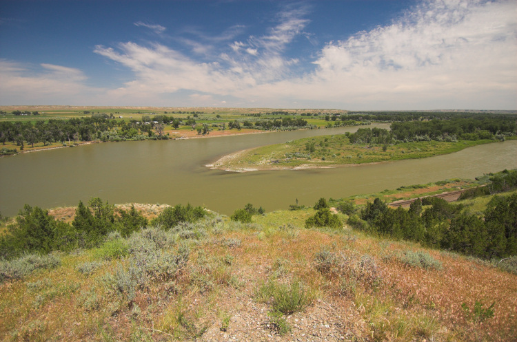
Vince and I are heading west from Belle Fourche for some late afternoon/evening photography around the Big Horn Mountains. We got wind from another storm chaser about a week and a half ago about amazing wildflowers right now west of Buffalo, WY, so we will head over there for a photography opportunity of our own. Tomorrow looks to be another chase day along the high terrain here in Wyoming as low level moisture returns northwestward on southeast winds. The mid-upper level flow will be fairly sub-par, however, southeast winds of 15-20mph can make up for that deficiency and directional shear will be pretty good to support a few severe storms. We will stay in Buffalo tonight. Beyond, there might be a chance we head up into Montana for two more chase days Friday and Saturday…with Sunday being a very long drive back to Dodge City to conclude this trip…. we will see.
Chase Summary — LP Supercell near Colony, WY
Vince and I began the day in Miles City with the primary chase target in mind being North-central North Dakota where low level moisture would be greatest and low level winds would be more backed. One problem was the cap, and we knew it would be very difficult to overcome given the lack of strong forcing. A secondary target closer to our location was to our southeast near Alzada, MT where low level moisture with dewpoints in the mid 60s would remain in place most of the day. The RUC model was showing this moisture mixing out by afternoon significantly reducing the CAPE… however surface observations just were not suggesting this. Just after we departed Miles City, we took a look at the new SPC Day One outlook update and they increased the tornado and hail probabilities in our secondary target area. Once again, I took another hard look at obs…and more and more, the 60s dewpoints from Sheridan to Gillette were just too much to ignore, plus I could see some low Cu on the visible satellite image just off the Big Horn Mountains near Sheridan, WY. We abruptly pulled off I-94 and abandoned our 6-hour pursuit to North Dakota. This was the big turning point of the chase… the quick decision to go after this secondary target that was much closer to us… with much less stress involved.
We sat in Baker, MT for awhile monitoring obs and satellite. More agitated Cu was developing near Sheridan and it became more and more probable that this is where we needed to be… or at least immediately downstream of this area… so we set our sights on Alzada. We drove south admiring the beautiful terrain and even stopped briefly for some landscape photos near Albion before continuing on with the chase. A quick gas stop at Alzada and we were on our way. Some nowcast support from Matt Crowther was helpful in determining our route. A storm was rapidly developing in front of our eyes to our west-southwest. We decided to go due west on a gravel road (Ridge Rd.) several miles. It didn’t take long for us to start seeing structure. We pulled off at a relatively high spot and admired the beauty in front of us. A barrel updraft became better established with a long beaver tail to the north feeding into the updraft. Our surface winds had a northerly component. The real-time motion in the updraft was just incredible. You could see the rotation real-time with the corkscrewing action in convective elements of the updraft. The character of the storm was on the dry side of classic on the supercell spectrum…but eventually, as we traced our steps back west, the storm would become more low-precipitation (LP) in appearance and would take on some of the most impressive LP supercell structure I’ve ever seen! The storm was moving east-southeast and we had to get back east to Hwy 212 so we could continue to stay ahead of it. We stopped a couple times on the highway north of Colony admiring the sculpted beauty. The blue sky behind the storm and the small precipitation shaft made for perfect photography light/color contrast. No words can describe the sight! We ultimately made it towards Belle Fourche, and the storm took on a different character again… looking more classic in appearance with a larger base. We shot more photos at a pull-off between Colony and Belle Fourche and learned of the gigantic hail the storm was producing… softball and grapefruit size hail!! Fortunately, we didn’t experience that as we stayed just far enough ahead of the updraft. The storm took a downhill trend as it moved northeast of Belle Fourche and we decided to head back west again after our final stop-off just northeast of town.
We went back northwest on Hwy 212 after we learned of new storms forming in the same exact location as our original supercell developed. (Thanks Dave Ewoldt!) Unfortunately, low cloudiness was increasing and obscuring our view as a strong cold front was pushing south. We decided to head back to Belle Fourche or Spearfish for the night…however on our way back, we learned that a supercell had rapidly formed again from that new activity… but we just couldn’t see what was going on given the low clouds. Nevertheless, the storm was moving straight for us and we decided to mosy west on I-90 to see what up. We got as far west as Buelah a couple miles into Wyoming. We noticed impressive anvil zits with high-frequency in the few holes in the stratus… it’s a shame the low clouds were as bad as they were. The lightning photography was really a bust from this storm. Eventually, we made it back to Belle Fourche again for the night after being chased to Sturgis by the supercell complex.
Again, what a day! Thanks again to Matt Crowther and Dave Ewoldt for nowcast support in our non-internet areas.


The following images are from the fantastic supercell thunderstorm that rolled east from near Roundup to Forsyth, Montana:


Vince and I left Miles City around Noon local time and was originally targetting the area 6 hours away over north-central/northeastern North Dakota… however, after the 1630 UTC SPC day-1 forecast came out… and a look at surface observations… we were convinced to play the secondary target much closer to us. We are now in Baker, MT as I type and we have lower 60s dewpoints here with light winds. The shear environment definitely supports supercells again today and I think we will be anticipating storms forming off the high terrain of the Big Horn Mountains near Sheridan…which will move northeastward into extreme Southeastern Montana… at least that’s the hope anyway. We will probably sit here in Baker until storms develop to the west or southwest of us.
Summary of Roundup, MT Supercell
(written by my chase partner Vince Miller)
What a day! Mike and I figured we would be at the rest stop west of
Miles City for at least 3-4 hours; it turned out to be 6. A line of Cu
to our NW to far W occasionally percolated during the late afternoon,
but was never able to sustain any long-lasting updrafts. About 6:30
p.m. MDT we left the rest area and drove 20 miles west to Forsyth,
keeping an eye on a area of Cu to the N which finally was achieving
some success at staying alive. A quick bite to eat was followed by the
decision to head WNW on US-12 to intercept supercells which were well
to the WSW of Roundup, while at the same time keeping an eye on the TCu
to our N which were showing serious attempts at punching into higher
levels of the atmosphere. The atmosphere punched back, however, and the
TCu rapidly became turkeys.
By the time we reached Ingomar (about 7:45 p.m.), the sun was just
disappearing behind the anvil of one of the supercells to the WSW. We
made a quick stop to take pictures and noted the winds were strong and
gusty from the north. As we drove a bit further W we were rewarded with
even better views of the backsheared anvil and a nice vertical wall on
the S side of the storm. Shortly afterwards, we were treated to a view
of a distant flared base (not of the southern most supercell}, and then
a complete view (and what a view) of the distant southernmost
supercell. We found a place to pull off the road to take pictures
(about 8:15 p.m.); our vantage point was 42 miles ENE of Roundup
(between Melstone and Sumatra). We decided to stay put because the
structure of the storms was fantastic. [Mike took many pictures over
the next 30+ minutes; I took some pictures and also time-lapsed the
storm during the same period. Our picture taking and time-lapsing
covers the time 4.25" diameter hail was reported at Roundup. Mike also
has some zoomed in photos of what may be a funnel; his photos are
within several minutes of the time of the funnel report near Roundup on
a Billings PNS statement.] The southern most storm had explosive growth
on its SE side during this time; we decided to backtrack to the east to
get a better vantage point for structure shots, and also because
lightning was becoming a distinct threat.
We stopped in Ingomar (a ghost town at best) for photography
purposes; storm structure was incredible, and lightning was increasing.
We had to abandon the picture taking after a while because of lightning
danger; so more backtracking to try to get ahead of the storm for more
structure shots and to get away from the lightning danger. During the
next 23 miles to the SE to Vananda we were treated to not only one
"mucho-supremo butt kicking storm", but also to a barrages of CG’s from
the storm’s anvil. Mike took some excellent hand-held photos of the
storm/lightning as we raced down the highway, and also some video on my
VX-2000.
We stopped in Vananda (another town which long ago lost whatever life
it had) so Mike could take some more structure shots – a dicey
undertaking by now. But, thankfully, the sparks from Thor’s hammer
stayed away from our immediate vicinity.
More backtracking towards Forsyth; we may or may not have seen a funnel
back-lit by lightning; we stopped several more times to take lightning
photos, and finally made it back to Miles City and the same motel where
we spent the previous night.
Vince Miller
Forecast:
Vince Miller and I are in Miles City, Montana this morning awaiting what could be a fantastic supercell day here around Miles City or south of here towards Broadus, MT. Lower to mid 60s dewpoints are streaming westward on east winds this morning north of a surface low over Wyoming. Mid and upper level winds are very good for this time of year and are more than adequate for supercells.. in fact perhaps a long-lived, significant supercell capable of greater than 3" diameter hail and/or (a) tornado(es). We’ll see. The road network is fairly sparse out over this area, however, the visibility somewhat makes up for this deficiency… you can see forever out here. They were right in calling Montana "Big Sky Country". After today’s chase… we will have to get east as tomorrow could be another potentially big severe weather chase day in North Dakota… more than likely east of Bismark. I will have no mobile internet access today where we are expecting to chase, so I will not have the website in "virtual chase" mode.
EDIT at 1:45pm CDT: I lied… I’ll go ahead and put the site in "virtual chase mode" since we will be along I-94 for awhile with internet coverage… however, once storms go up and (if) we leave the interstate, then the coverage will be gone over the rest of the expected chase area… so if the radar graphics stop updating, that’s why.
EDIT at 2:30pm CDT: We are stopped at a rest area on I-94 about 25 miles west of Miles City to a wonderful vista view overlooking the Yellowstone River. If anything develops within 100 mile radius of us.. we’ll see it! What a view!
It is late afternoon and we are driving towards Devil’s Tower in Wyoming for a little evening photography before settling in tonight at Miles City, MT. We spend the early afternoon today in Rapid City, Vince needed to get an oil change in the car and we had a nice little sit down lunch at my favorite brew-pub up North called the Firehouse. Anyway, I think tomorrow looks like a potentially great day for southeastern Montana supercells… a classic looking "north of the low" setup for eastern Montana with fantastic low level moisture and very nice deep layer shear. Sunday appears to be somewhere over central/eastern North Dakotat per the latest GFS/NAM model runs.
Jon Finch: I knew you’d probably question our no-go for Canada .. we just thought it would be at least 100 miles north of the border (and by the looks of radar right now, that appears to be verifying)… and by the time the chase would end at like 10pm or so… we’d be well into Manitoba… and realizing that Sunday and Monday looked almost just as good in terms of CAPE/Shear combo… well.. we thought we’d take a pass on the first of what looks to be 3 pretty good (tornadic?) supercell days. We may miss a big tornado today by not driving our brains out to get to Canada, but there’ll be more opportunities I think… you know me, I’m a structure guy anyway, and as far as photography goes, the structure/scenery of the Chadron supercell yesterday was better than about 2/3s of all tornadoes I’ve seen (contrast, visibility, longevitiy, etc).. I think tornado prospects Sunday and monday look pretty darn good… As much as you despise the really low elevation of eastern Montana, I still think there’ll be a decent tornado prospect out this way with east winds, fairly low LCLs and what looks to be really good shear.
EDIT at 8:23pm: Well, maybe we did F this one up. Sitting here at Devil’s Tower and pulled up a radar image from Minot. Ouch. It’s also moving southeast towards the US line. We took the model runs a day and a half ago hook-line-sinker that things the best beastie today would be about 150-200 miles north of the border. Oh well.. can’t go back and try this one again. Time to look forward to tomorrow and Monday.