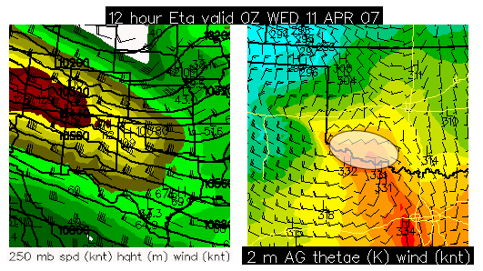
Another marginal day, but… There is the potential for a nice little surprise along the Red River over far Southwest Oklahoma. I will be chasing today because it is my only day off this week and I will not be able to chase Thursday (which looks quite a bit more promising), so I need to make hay while the sun shines! I will be targetting the area shown below in the graphic late this afternoon/evening — a favored region at the nose of a strong upper level jet where surface cyclogenesis will be maximized. The NAM and RUC show increased moisture over this area… a little more moisture than previous models runs of the NAM were suggesting, thus CAPE will probably reach 1000 J/kg over this area as well. I’ll be departing Dodge City around 11:00am (in about 50 minutes). For those "virtual chasing" with me today, I’m not sure how good the cellular coverage will be in Southwest Oklahoma… I know that en-route through Northwest OK I will have essentially no data signal at all, so you probably will not see updates until early afternoon when I get south of I-40.
"Cold-core" setup?? I am planning to chase far eastern NE/extreme western IA tomorrow as it looks like there could be a localized sweet-spot near or just north of the developing surface low by early-mid afternoon… as a powerful upper low ejects northeastward. The NAM and RUC models both depict a north-south quasi-stationary front position north of the surface low which may act as source of rich vertical vorticity which seems to be a very important ingredient for tornadoes near closed cold-core upper lows. I am heading to Kansas City this weekend anyway, so this chasing location really won’t be all that bad for me… as I’ll be heading back "home" home (Overland Park) after this chase to spend the rest of my 3-day weekend with fam and friends. Below is a surface forecast chart from this evenings NAM model run with the white transparent oval indicating my first-guess target area:

Target: Akron, CO. Interesting day today. This is one of these really marginal days that could make me look like a fool if nothing happens…or a genius of something picturesque develops by early evening. The big problem with northeastern CO today will be moisture. Winds are light and out of the northwest currently (~8:30am CDT) over northeastern Colorado with dewpoints in the 30s… not exactly what you look for in your target area…however, all the models suggest winds will rapidly veer to the east-southeast by this afternoon. The question is how fast the moisture can race back northwest to meet up with the strong forcing for ascent which the NAM and RUC certain suggest quite well between Denver and Akron or so by 00z. It will be a late show. I was briefly tempted at a secondary target near Clayton, NM, however, my gut just wasn’t feeling it…despite the better moisture. Boundary layer temperatures per NAM and RUC show warmer temps up in the high plains of Colorado east of the front-range, so lapse rates will be steeper farther north it appears…which would compensate for moisture deficiencies and strong forcing for ascent to get a good storm to develop. It seems there’s really no rules for Colorado convection… if you have upslope winds and insolation and just a little bit of juice, anything can happen. Chasing farther north will put me in better position for tomorrow anyway, which looks more promising than today’s chase.
Since I have 3 days off this weekend, I have decided to make a chase trip out of it. It does not look like the best chasing opportunity to ever come, but there’s certainly a chance at picturesque storms where I love to chase — the central H igh Plains. Friday 3/23, it looks like upslope flow will advect enough low level moisture into northeastern Colorado…along with steep low-mid level lapse rates…to promote a decent chance of chaseable storms…and perhaps a (marginal) supercell. I’m thinking of an area around Akron, CO for starters tomorrow. A nearly stationary upper low over the Southwest will lift north-northeast on Saturday 3/24 into eastern Colorado. At this time, it appears an area from far northeastern CO into far northwestern KS and far southwestern NE (what I like to call the "CONEKS" region) will be the best area for interesting chaseable storms just downstream of the ejecting upper low. With two days looking good enough for me to get me out the door this early in the season, I am pretty much making a "Go" decision, leaving early tomorrow morning for Northeastern CO and probably staying the night somewhere in Northeastern CO for Saturday’s setup. A couple charts below from this evening’s NAM model run show my first-guess target regions for Friday (top) and Saturday (bottom):
This will be my first good test at my "virtual chasing" on Underthemeso.com where visitors to the website can keep up with my near-current location out on the Plains. My main front page at www.underthemeso.com will be directed to a secondary index page made especially for monitoring my storm chase. I’ll have that setup for both Friday 3/23 and Saturday 3/24.

Tuesday the 20th is a work off-day for me, thus I plan to make it a chase day since there is a reasonable opportunity at a supercell within a half day’s one-way drive. All along, it looked like Iowa was the place to be for Tuesday the 20th… and it still does… however, Northwest Iowa is not a reasonable target for me from Dodge City. I’ve already done the Dodge City to Sioux City drive once this season… I think one time is enough, LOL. Since there is a reasonble opportunity for supercells closer (still 4+ hours away), I will opt for a closer play. Pretty strong zonal flow aloft with a short-wave trough embedded in the westerly flow will allow for organized storms in two areas it appears: Northwest to North-Central Iowa… and Northeastern Colorado. The better wind profiles and CAPE/moisture will be in northwest Iowa, which is where the best opportunity for tornadoes will be. The cold front will move south into western KS during the day tomorrow… however, the front will stall out given the strong zonal flow aloft. North surface winds in northeastern Colorado early in the day will turn to northeast then east by late afternoon/early evening… increasing shear and allowing post-frontal low level moisture to advect west. Storms should develop in terrain favored areas like the Palmer Divide and the Cheyenne Ridge. I am shooting for a target around Akron, CO at this point.
Below is the 24hr forecast from the NAM model valid 6pm MDT tomorrow (850mb Theta-E and wind). Note the warmer colors in the image (indicative of greater instability) in northeastern Colorado with easterly component winds advecting higher theta-E into northeastern Colorado.

For those who know how to read Skew-T (thermodynamic) diagrams, here is one for a location near Holyoke, Colorado (a 24hr forecast valid 6pm tomorrow) . Holyoke is in extreme northeastern Colorado about 30 miles south of where I-76 and I-80 merge.
90/55°F surface parcel yeilds about 1600 J/kg of CAPE. 0-6km shear is forecast to be about 40-45 knots by 00z, which is sufficient for supercell structures. Both the NAM and the NAM-WRF generate decent storms by 00z in this area with storms continuing well into the evening with high QPF values at 06z.

I am in Ogallala, Nebraska with Jim Leonard, Mike Theiss, and the Cyclone Tours. I’ll be chasing with them for the couple remaining days of my vacation. Looks like an interesting day in Southwestern South Dakota atop the upper ridge. Decent deep layer baroclinicity with adequate (yet still meager) moisture for supercells. Even though the 500mb winds will be fairly weak ~20 to 30 knots, a look at the forecast hodograph for the area reveals good length thanks to strong low level flow. The NAM shows a nice looking curved hodograph with a deviant storm motion of southeast at less than 10 knots. Storms should develop in the Rapid City vicinity and this is where we’ll be heading. Thursday (June 8th) looks like the same general area.
Stacie and I are at Jay’s in Lawrence. We drove all night down I-29 from North Dakota and arrived in Lawrence around 8:30am. Rob, Mitch, and Jon all went to Jon’s place in Olathe, so we are temporarily away from them… but it appears we will rejoin them this afternoon in our target area around the Hutchinson-McPherson area.
A remnant cold front will continue to stall out over this area today. Pretty good heating will occur on both sides of the boundary and if any strong updrafts can remain rooted right on this boundary, then non-mesocyclone tornadoes can be possible if things pan out right. This would be the only hope at a tornado today. Several of the components necessary for these types of events will be in place today. Storms should be moving quite slowly, thus significant updrafts should have an easy time developing/feeding on mature storms. In fact, if a marginal or bonafide supercell develops today, it would likely move south or perhaps slightly west of due south… not unlike July 9, 2003 Reno-Kingman county non-mesocyclone tornado event. We’ll see how it plays out.
We’ll depart Lawrence probably around 1pm.
Stacie’s driving so I get to browse the internet here as we are driving on I-94 towards BIS. We left DIK about 40 mins ago… looks like we are driving into the warm sector now. Nice low strato-cu poleward of the front, indicative of the adequate moisture in place. With strong cyclogenesis over WY today, I think our front will be undergoing slight frontolysis, but not enough to prevent the adequate convergence for initiation just west to northwest to north of BIS. Will hang in Manden probably. I hope the storms can move northeast of the Missouri RIver early enough. Upper winds are lacking, but good directional shear from BL to 6km… thank goodness for that. I expect HP end of things today with the weak mid-upper winds.
Just got off the phone with Jon… Rob, Mitch, and Jon are now at Fargo, ND and are about to head west towards Bismarck. So they are now on track to meeting up with us around or just before initiation time.
Morning analysis shows a sfc low near Miles City with lower 50s dewpoints in northeastern MT. Looking at the 06z NAM, it appears this first sfc cyclone will continue moving northeast into western ND….with a weak front moving south into far southeastern MT by early afternoon. As this is happening, significant mid level flow perpendicular to the Big Horns will support pronounced lee cyclone development downwind of the Big Horns. The NAM has been showing this for many runs. Looks like that front will stall along a line roughly from Sheridan to Broadus to Capital. Winds east to northeast of this boundary will advect in near 50 dewpoints in this area it appears. 87/50F sfc parcel supports about 1300 to 1500 J/kg CAPE along this axis from Broadus to Capital by 00z. The shear profile looks very good with a broad looping hodograph in the 0-6km layer. This environment certainly supports supercells. Looks like we may head north to Broadus this afternoon.
Good morning from Gillette, Wyoming. This is as far northwest as any of us have overnighted on a chase trip. We left Scottsbluff, NE after lunch and visited Scottsbluf Nat’l Monument for a little sightseeing. The views from atop the bluffs are pretty amazing… what a great location to watch a supercell from! Here’s a group shot overlooking the city of Scottsbluff:

L to R: Matt Crowther, Stacie Hanes, Steve Wachholder, yours truly, Jay Antle, (Papa Cyclone) Jim Leonard
We then set off for the Devil’s Tower Nat’l Monument arriving there around and hour and a half or so before sunset. The drive up there was quite nice actually, it’s amazingly green out here in northeastern Wyoming. Some of the spring snows have really helped this area out. A marginal supercell thunderstorm developed northwest of Broadus, MT which was visible to our distant NNW from about 150 miles away. It was amazing I was able to hold a digital cell signal and download data at numerous points during the drive from Lusk to Sundance, WY. As we approached Devil’s Tower, that particular storm was weakening somewhat:

We spent a couple hours touring around and photographing Devil’s Tower. We were fortunate enough to have some cirrus clouds and good low sunlight to make the scenes more photogenic:

We arrived at our expensive Clarion Hotel (the only decent place we could find with available rooms given Memorial Day Weekend approaching and being on the interstate halfway between two of the most popular tourist destinations in the country — the Black Hills and Yellowstone.
Today (Day 4, Fri 5/26) looks like a chase day. We will be playing far southeastern Montana it looks like. I think a supercell storm can develop in the area northeast of Billings to Broadus… along the deep layer baroclinic zone. We should see CAPE values around 1000 to 1500 J/kg I think. The forcing will be better than yesterday, so I think there’ll be more storms. We already have reservations for Dickinson, ND in anticipation for what looks like a pretty good Day 5 (Sat 5/27). Jon, Rob, and Mitch will be driving up from Kansas City beginning tonight and will join us for Saturday’s chase. More later!