High Plains Drifter


disclaimer:  "The meteorological views/forecast thinking expressed are those solely of the author of this blog
and do not necessarily represent those of official National Weather Service forecast products,
therefore read and enjoy at your own risk and edification!"

May 2, 2010

Chase Trip Day Seven (4/30) Summary [19 images]

Filed under: Early Chase Trip 2010,Photography — Mike U @ 1:00 am

No storm day, drive to Clayton, NM photographing scattered showers with landscape of Western Oklahoma Panhandle.

(rest of images at the bottom of this post)

I slept in until noon and got a new tire put on my Jeep first thing.  Cumulus were developing from northeast to southeast, and after I got back home around 1:30pm, I quickly packed things up again, looked at a couple of analysis maps, including the short-fuse composite and 1km visible image, and decided to head east toward Pratt and get closer to the agitated cumulus.  Problem was that the convergence zone was shifting rapidly east to Wichita… and the original focused area of cumulus near Coldwater and Pratt waned with renewed cumulus developing well to the east in the Hutchinson to Newton areas.  I abandoned this jaunt about 30 minutes into the drive after realizing this would be a fool’s errand.

So I started looking at things and decided that I was going to do some hiking in the Caprock Canyons or Palo Duro Canyon the following day since it appeared the next chasing opportunity would be Sunday the 2nd.  I had to head back to Dodge and pick up my hiking shoes though, because in the rush to leave, I forgot to pack my hiking shoes.  I looked at the models one last time and thought that sightseeing/hiking and photographing some of the showers around Capulin Volcano the next day (Saturday 5/1) would be the most interesting thing to me… so that’s what I decided to do.  After I picked up my shoes I set off south toward the western Oklahoma Panhandle.  Showers had developed in the cold air aloft, around -22 to -24C at 500mb, which were producing some nice virga shafts when I reached the Oklahoma Panhandle.  My route took me to Guymon then west to Boise City.  One of the more interesting things photographed was a decaying shower that was elongated east to west in a peculiar wave structure, kind of like Kelvin-Helmholtz waves, but the wavelengths were quite long and didn’t “break” like K-H waves usually do.  It was interesting nonetheless, whatever nomenclature you wish to attach to it!  From Boise City I continued west to the New Mexico line northeast of Clayton and photographed fairly colorful virga/rain/show showers to the distant north from a location between Clayton and Kenton.  I tried to use some foreground subjects to my advantage to enhance the images, like usual.  I also used the circular polarizer for most of my images as well.  Overall, the sunset colors were sub-par given the sun going behind clouds as it was setting after 8:00pm (CDT).

Begin:  Dodge City, KS (home)
End: Clayton, NM
Day Seven Mileage: 346 mi.
Trip Mileage: 3193 mi.

This SimpleViewer gallery requires Macromedia Flash. Please open this post in your browser or get Macromedia Flash here.
This is a WPSimpleViewerGallery

May 1, 2010

Chase trip day Eight coming to a close

Filed under: chase mode updates — Mike U @ 7:34 pm

I am on my way back to Dodge city after a fun day landscape and sky photography across north east New Mexico and south east Colorado. I should be at Dodge city by 10:30 PM, more later.

[ Transcribed by MyCaption ]

Dissipating snow shower

Filed under: chase mode updates — Mike U @ 3:09 pm


Northeast of Folsom, NM

Snow showers from atop Capulin Volcano

Filed under: chase mode updates — Mike U @ 1:31 pm


This one shower has a nice organized looking small base!

Chase Trip Day Eight (May 1) Forecast

Filed under: Early Chase Trip 2010 — Mike U @ 10:38 am

More of the same:  Glorified High Plains Rain Showers! Very cold air in the mid levels on the order of -22 to -24C will continue across the central High Plains.  Showers will develop first over the higher elevation of the Raton Mesa then spread east into southeastern Colorado and eventually far Southwest Kansas by early evening.  My trek today will take me to Capulin Volcano first, then following these showers and hopefully some good photographic light back into far southwest Kansas.  Will be overnighting back home in Dodge City tonight.  Sunday continues to look interesting across Kansas, mainly central KS perhaps around Salina, as some residual low level moisture sneaks back northwest beneath the very cold temperatures aloft creating CAPE around 1000 to 1250 J/kg.  The NAM has been persistent in developing a “QPF bomb” during the 00z to 06z time frame, so I think some organized deep moist convection will likely occur… just a matter of where at this point.

Chase Trip Day Six (Apr 29) Summary [20 images]

A dryline bust saved by late storm initiation on the cold front at Wilson Lake, KS.

(rest of images at the bottom of this post)

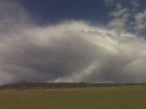
My target all along was the dryline just south of the cold front — somewhere from Great Bend to Pratt.  I didn’t waver from this target, except briefly right after I had lunch in Hays when cumulus was already forming from west of Salina to east of Hoisington.  I drove south from Hays after lunch, which pretty much sealed my fate for chasing the northern storms that 97% of the other chasers were chasing.  Once I reached La Crosse, KS, I turned east to Hoisington watching the southernmost cumulus congestus to my east-northeast.  Briefly, I thought this would be the intercept.  I then noticed more aggressive cumulus growth to my south in my original target, so that was the clincher for me.  I blew off that congestus to my east-northeast and dropped south from Hoisington.  1km visible satellite also confirmed this nicely with a clumping cumulus field centered across Stafford County and points south-southwest of there to between Greensburg and Pratt (4:30pm).

I made it down to Stafford which was where I decided to stage between 4:45 and 5:15pm.  Nothing was happening with my cumulus field to the west through southwest… and I was becoming increasingly anxious.  The best convergence on the dryline appeared to be shifting north a bit, so I moved back north and sat again along a farm road from about 5:30 to about 6:30.  I spent most of this hour interrogating the models for the next couple of days of my vacation.  Still nothing to my west through southwest.  In fact, what cumulus was developing was quickly turning into a big area of virga.  This wasn’t good!

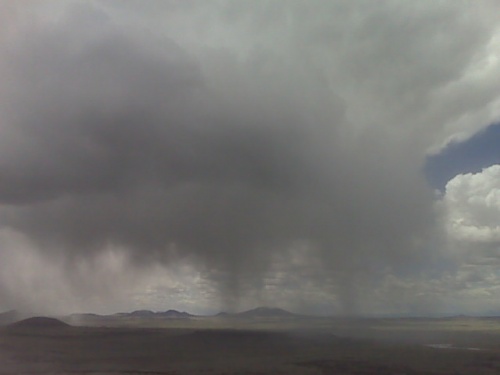
The NAM and GFS models were insistent in vigorous convective development in the 00z (7pm) to 03z (10pm) time frame… right around sunset, with the southern edge of this vigorous development right about Great Bend.  I felt very confident storms would eventually develop, but along the cold front instead.  The cold front was slowly moving south toward the best dryline convergence.  It was just a matter of time before initiation.  In the meantime, I trudged north on farm roads (7:30pm), watching this huge area of virga shower activity from my northwest through southwest.  You could make out some bases in spots, but nothing that said “come chase me” yet.  It was just about to go.  So I continued my merry way north (8:00).

Once I reached I-70 at around 8:30pm or so, the atmosphere finally let loose:

Intense development along the cold front all the way down to southwest of Great Bend!  There were embedded mesos in spots along this line of convection, and the one I concentrated on was just west of Wilson Lake.  There was a good view from Wilson Lake, so I decided to stop here and begin shooting.  I was greeted to some insane inflow winds from the southeast!  I estimated winds in the 50-60mph range… which was difficult to stand in, let alone to try and photograph in… or even set the tripod up (after all it was now 8:45 by this time and light was low!).  Electrical activity was pretty good in the updrafts, and I managed to capture this to some degree in the stills.  Since the activity was moving northeast instead of straight east, it allowed me to drive east and stay ahead of the storms… stopping for about 5-10 minutes to shoot, and then repeat.  I continued east from Lincoln to Beverly.  The best storm on the line now appeared to be to my southwest, so I headed south on an unpaved farm road from Beverly at around 9:45pm.  This turned out to be a fateful move.

I blew out my front driver’s side tire.  On a dirt road.  With a storm to my west about a half hour away (10:05pm).  I could still drive on the flat, but no faster than 20 mph.  It was imperative I find pavement, and thankfully I was only 3 or 4 miles from an I-70 interchange west of Salina.  I limped south and by a stroke of luck, one of the next east-west county roads was paved!  I stopped here.  Since this was a new Jeep that I had not changed a tire on before, I had to learn the little idiosyncrasies for spare tire changing with this vehicle on the fly… with a storm headed my way.  I didn’t think I had any time before the storm hit, so I resorted to just photographing the damn storm updraft, since it was fairly photogenic…

The cell to my immediate west would miss me to the north, and I just got a few big rain drops (10:30pm) and it ended shortly thereafter.  I had a brief window of opportunity to get the spare tire on before the next cell hit.  That window was about 15 minutes…

…It took me longer than that to complete the job, because I started to get poured on shortly before 11:00pm.  So now it was a waiting game… with my vehicle jacked up.  So now I’m sitting in my Jeep with west winds gusting to about 60 mph rocking the Jeep a little bit while it was jacked up.  I felt pretty confident that despite these winds, the jack would hold.  And it did.  So now I know I can have the vehicle jacked up in 60 mph winds, LOL.  Not again, though.  Next time, I will have it calculated down IN ADVANCE how long it takes me to change a tire.  As much storm chasing as I do, this is the #1 reason for a break-down.  A flat.  It’s happened a number of times to me, my chase partner’s vehicles, or other chaser’s vehicles that I’ve assisted on.  I had planned on doing a practice tire change before my trip, but I simply ran out of time preparing for my trip in other areas.  It ended up biting me.  But I got the job done.  When this vacation is over, I’ll do another practice spare tire change and time myself so I know exactly how long it SHOULD take, if I’m chasing solo.

The rain finally let up enough to get out and finish the job at around 11:30pm, and I was back on the road.  At this point, I was obviously done chasing given the time and the activity to my east, so I began my trek back to Dodge City.

Begin:  North Platte, NE
End: Dodge City, KS (home)
Day Six Mileage: 620 mi.
Trip Mileage: 2847 mi.

20 images from this day’s shoot:

This SimpleViewer gallery requires Macromedia Flash. Please open this post in your browser or get Macromedia Flash here.
This is a WPSimpleViewerGallery

April 30, 2010

chase trip update 4/30 8:45pm cdt

Filed under: chase mode updates — Mike U @ 8:52 pm

Just approaching Clayton now. I had a fair day of landscape + sky
photography of scattered virga showers. These provided for some
decent photographic opportunities…however the color at sunset didn’t
really pan out like I had hoped. Still got some okay images late this
afternoon through the mid-evening hours. Tomorrow is May 1, and I
will spend tomorrow afternoon at Capulin Volcano. Some additional
showers are expected to form along the Raton Mesa given the very cold
temperatures aloft, so there may be a repeat tomorrow of what I did
late this afternoon/evening. I will then head to Dodge late tomorrow
evening, as Sunday May 2nd could be a chase day across Southwest
Kansas, if this morning’s NAM model was right… 800 to 1000 J/kg CAPE
with some low level convergence amidst cold temperatures aloft. This
just may be the last hurrah for chasing/photogrpahy during my vacation
time. Monday and Tuesday I may be spending in Dodge for the end of my
vacation as the severe weather pattern is crap these days it continues
to appear.

« Newer PostsOlder Posts »

Powered by WordPress