Slow-moving storm = prolonged winter weather. Here’s the first post of probably many, as another interesting winter storm is developing out over the Southwest. For western Kansas, it appears as if the biggest concern initially will be with freezing drizzle late Friday into Saturday. The first "wave of energy" will prompt snow development from eastern Wyoming into western Nebraska Friday night and Saturday. A shallow cold airmass will ooze south, with sub-freezing temperatures at the surface expected to overspread  Southwest Kansas, including Dodge City. Included in this post is the NAM 36-hr forecast at 750mb (roughly 6500ft above Dodge City elevation) and 900mb (rougly 1100ft above Dodge elevation). Warm air aloft will overspread the shallow cold air at the surface, which is illustrated in Img 1 by the NAM model. Just north of the shallow cold airmass, substantial warm air advection and moisture will allow the development of drizzle/freezing drizzle, depending on the surface temperature.
Beyond Saturday, the forecast is real fuzzy, as the upper trough stalls out over the Desert Southwest with smaller scale disturbances rotating around the upper trough axis. The individual mid-upper level jet streaks will dictate the lower level response and subsequent significant precipitation development. From a pattern recognition standpoint, given the configuration of the upper trough with substantial warm air advecting north in the 800-700mb layer coupled with shallow arctic air near the surface, a significant ice storm may be had over some (or a lot!) of the central Plains, including much of Kansas. Img 2 is a 3-panel model comparison among the Canadian, GFS, and NAM at 60 hours valid 6am Sunday 12/9 at 700mb. Here are some of the 12-hour precipitation accumulation from the GFS, NAM, and Canadian models for Dodge City, Saturday through Tuesday:
Model: ending 6pm Sat || 6am Sun || 6pm Sun || 6am Mon || 6pm Mon || 6am Tue || Total
GFS: 0.02 || 0.50 || 0.01 || 0.00 || 0.30 || 0.00 || 0.82
NAM: 0.01 || 0.01 || 0.10 || 0.21 || —- || —- || 0.33
Can: 0.00 || 0.00 || 0.08 || 0.00 || 0.20 || 0.24 || 0.52
*NAM model only goes out to 84 hours.
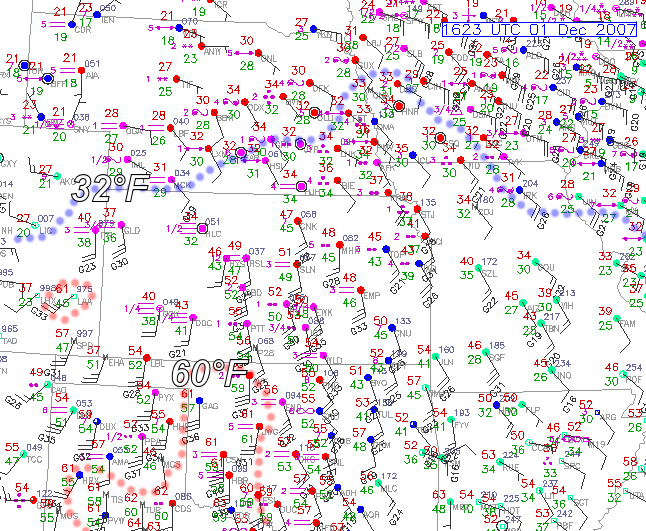
So much for appreciable precipitation in SW Kansas. Well, it’s now late morning amidst dense fog here in Dodge City, as surface moisture has rapidly surged north into the remnant shallow cold airmass. The freezing line has shifted way north into Nebraska by now. We observed very light freezing rain and freezing drizzle here in Dodge City from roughly 3:30-6:30am. Total precipitation measured at the airport (from the ASOS) was a whopping 0.01". Up at Hays, it looks like only 0.03" was measured at the AWOS station. Hays went above freezing at roughly 5:30am, several hours sooner than thought. The warm, moist air really surged north rapidly this morning. There were pretty much no impacts across this area from freezing precipitation, as a result. Now we wait on the wind… we’ll see how this aspect of the storm verifies. I was expecting far southwest KS to see some 60 mph gusts later on this afternoon. Now, the real winner (or loser) of this storm from the winter precipitation aspect is Iowa into adjacent southern Minnesota. Major icing going on now across Central Iowa from what it looks like per obs and radar. Here is the Nowcast Thread on Stormtrack forum from other storm chasers and genuine weather weenies talking about that. Back to the high plains region, It’s already 60°F in Lamar, CO from the downslope. Below is the 16z (10am CST) surface chart:
The dreaded Rain Shadow. This post will be real brief. I’m not liking the new QPF trends from the numerical models for Dodge City and the rest of western Kansas. I attached one image on this post, a 36-hour total precipitation graphic from the NAM model ending 12z (6am) Sunday Dec 2. We will be completely rain-shadowed from the Pacific moisture, which always happens, given the geography. The gulf trajectories and the shape of the low level jet do not favor significant precipitation in western Kansas. Typically, you want to be on the north side of the low level jet, where convergence occurs, to get appreciable precipitation. This will be way northeast of Southwest Kansas. I’ll be surprised if there is even .25" of precipitation over any portion of the western 1/3 of Kansas. There’s nothing on the radar yet, except for in New Mexico as of 930pm CST.

 Still in the 20s! It’s cloudy and cold right now in Dodge City with the 3pm temperature of 28°F — a far cry from the lower 40s the GFS and NAM had for highs for us just yesterday. Maybe one of these days, the boundary layer non-hydrostatic physics will improve in the NAM model, and shallow arctic airmasses on the High Plains will be better forecast. So, it’s colder, and also drier, with a dewpoint in the single digits. It’s a no-brainer that our precipitation type tonight will be in the form of freezing rain (maybe some sleet mixed in initially). The question, then, is how much precipitation will we get? At this point I’m thinking about 0.15" of mainly freezing rain here in Dodge City. By the time the expansive precipitation area
  organized later tonight and into tomorrow morning, the "show" will be lifting rapidly northeast of here. The two graphics I present in this post are the 21z (3pm CST) surface observations in Img 1 and the 3-hr forecast of surface temperature and wind from the NAM model in Img 2. As you can see, across pretty much all of western Kansas, the 3-hr forecast (3 hour!!) is off by a significant margin.
Thursday evening 11/29 update. Not a whole lot has changed in the model data today actually. It still looks like it will be too warm for significant freezing rain, except for north central and northeastern portions of Kansas. In the DDC NWS forecast area, this would most likely be the Hays-Wakeeney areas. The day shift  issued a winter storm watch to include as far south as Dodge City. The surface temperature will have to be a little bit colder than any of the models are suggesting at this point for any freezing precipitation in Dodge, but it has happened many, many times (surface temps colder than any of the 36-48hr progs suggesting). I’ve included a couple of interesting graphics showing the model depiction of the low level warm air advection with this strong storm. It is about as impressive of warm air advection as I’ve seen here in the western Plains given the combination of tight temperature gradient + wind magnitude. The first image (Img 1) is a 30-hour progression of the 850mb pattern (temperature, wind, and height) showing the modified arctic boundary retreating northward on southwest 850mb of 50-60 knots! In the next image (Img 2), I show the NAM model surface forecast from this morning’s run with temperature, wind, and sea level pressure. I annotated the front on this image, denoted in the solid red
 (warm front) and red-blue alternate (stationary front). I also depicted a sort of "secondary" downslope front in a lighter red shading. I think in this airmass, temperatures will get very mild with very strong winds expected amidst deep mixing. In Img 2, I annotated in dotted line roughly the 32°F as forecast by this morning’s NAM model. You can see that the NAM only shows surface freezing temperatures only as far south as about I-70 — with about 35°F or so in Dodge City between midnight and 6am. Five degrees colder, and of course there could be some problems if there is significant enough precipitation (hence the Winter Storm Watch).
High Wind Warning Criteria? Then there is the wind aspect of this storm on Saturday. Significant cyclogenesis is expected across eastern Colorado on Saturday with a surface low perhaps as deep as 988mb! The pressure/height gradient up to 700mb will be very tight with 50-70 knots expected from 800-650mb or so. As mentioned previously, the locations that get into the "downslope" airmass across far  Southwest Kansas in particular, will be susceptible to perhaps 60mph wind gusts! The third image in this post (Img 3) depicts the GFS forecast 750mb Wind. The wind speed on the graphic is in knots. I also overlayed the surface wind on top of the 750mb to get an idea of directional vertical wind shear. This is important for sufficient "mechanical" mixing. The less the directional wind shear across the layer, the easier it is for mixing of momentum in the layer, given steep adiabatic (or nearly adiabatic) lapse rates. Across far Southwest Kansas, the surface wind will likely be veered enough with very little directional shear to 750mb (the area depicted west and south of the dotted red line in Img 3). Thus, it would be easy for the atmosphere to mix down those 750mb winds in gusts at the surface. 750mb wind speed forecasts for Saturday afternoon are in the 55-60 knot range! We may be looking at some high wind warning criteria winds across portions of Southwest Kansas Saturday afternoon. More later. -Mike U
Well.. maybe The Weather Channel will be right after all!! I love this job. Here I was explaining in my previous post how The Weather Channel’s supposed "rediculous" high in the mid 60s didn’t have much merit given how shallow arctic cold air masses this time of year usually "work" around here…. but there is little support now in the cold air "hanging tough" on Saturday. I had to update our forecast here at the NWS here in Dodge City for higher temps Saturday. If there is going to be any freezing rain, it will be during the midnight to 6am time frame early Saturday morning… before the massive warm air advection overtakes the remnant modified arctic airmass. Now, if you lived in, say, Sioux City, Iowa… or anywhere else in Iowa for that matter… get ready for some nice winter precipitation! -a humbled Mike
Ice problems Saturday (Dec 1) across portions of Kansas? It sure looks like this is a plausible scenario. This is the first post of several, I would imagine, as I have interest in this system from a forecasting standpoint and the complexities of precipitation type forecasting. Look for official National Weather Service forecasts concerning this system for Southwest Kansas, issued by yours truly, as I’ll be working midnight shifts forecasting for the Fri-Sat time period (Nov 30-Dec 1). Anyway, the first post about this storm relates to the different forecasts for Saturday, Dec 1st (and oh are they different!) among the Weather Channel, AccuWeather, and the National Weather Service. Refer to the following images. The set of images below are forecasts for Saturday in Dodge City from each of the three services:
AccuWeather ^

The Weather Channel ^

National Weather Service ^
The temperature forecast challenge, as you can see just by comparing these 3 forecasts, is about as great as it gets. That said, biases aside, I believe the National Weather Service forecast, given local expertise, is the superior forecast, especially considering shallow arctic airmasses. An arctic front will push through Friday, and numerical models always have a hard time with a) the degree of cold air pushing south and b) scouring the shallow cold airmass out too fast. This has huge implications, of course, for precipitation type. Currently, only the National Weather Service is forecasting any possibility of freezing rain. Neither the Weather Channel nor AccuWeather show any possibility of freezing rain — even for Hays, KS north of here (images not shown, but I have them available!). This post isn’t to rag on the other weather services, because the storm hasn’t even occurred yet, but I will say that given the lack of local expertise from The Weather Channel and AccuWeather, their High Plains weather forecasts will almost always be inferior to those forecasts from the meteorologists who actually live out here and know the local tendencies, for instance, when shallow arctic air invades in the winter time. We’ll see what happens, it will be an interesting storm to say the least! I love forecasting winter weather! -Mike U
About 1.5" in the backyard. It’s still snowing lightly out there during the mid-evening hours. I went out to the backyard where it appeared there was a more even distribution of the snow cover and came up with about 1.5" or so. Looks like a lot of areas around here are in the 1-3" range… a fairly even distribution around Southwest Kansas. So the first 1" of snow has arrived here on November 23rd. On to bigger and badder snowstorms!!

12:25pm. Moderate Snow… quickly all-white cover! We should be in decent snow for the next couple of hours. Here are a couple of photos I just took out my front door:
-repost. originally posted 12:25pm CST


