 Monday-Monday Night looks quite interesting now! Wow, the GFS and Canadian 00z model runs this evening paint a rosy picture for winter storm fanatics like myself! The upper level wave formerly referred to as "wave #3" in my previous posts will likely infuse an exorbitant amount ofGulf Moisture with low level trajectories favorable for significant western Plains precipitation. A "kicker" jet-streak digging down the backside (what I guess would call wave #4) will eject the primary storm northeastward in a highly energetic fashion — according to the 84 hour forecast of the latest Canadian and GFS models. 12-hr precipitation accumulation from both models peg a 1.25 to 1.50" max during the 6pm Mon to 6am Tues time frame (see Img 1). The Canadian is farther west, with this maximum occurring between Dodge City and Wichita, whereas the GFS has a narrower corridor of significant precipitation through central Oklahoma. Precipitation type will be a huge dilemna, as it would certainly appear that a warm layer aloft would advect northward overtop the shallow cold airmass. There could be significant sleet and/or freezing rain around portions of Southwest Kansas Monday night.
and do not necessarily represent those of official National Weather Service forecast products,
therefore read and enjoy at your own risk and edification!"
December 8, 2007
Great Plains Winter Storm Dec 8-10 [post 5]
Great Plains Winter Storm Dec 8-10 [post 4]
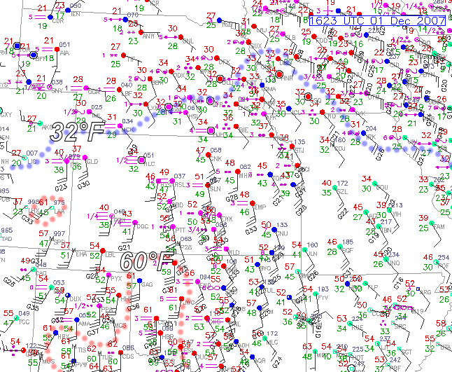
 It’s getting icy out there! Well it’s midnight, and upon stepping outside, it doesn’t take much to lose your step. About 3/4 of my driveway is icy vs. wet, although the street itself is still just wet as the road temperature is probably still just barely above freezing. Air temperature is hovering between 28 and 29F (see midnight surface plot in Img 1). I’ve also attached to this post a radar image from midnight showing the freezing drizzle. Freezing drizzle has a unique signature on radar, since it is such a shallow, near-surface layer of precipitation formation. You can only detect drizzle or freezing drizzle usually out to about 30-40 miles or so, at the lowest elevation slice. The radar image I attached (Img 2) is a 1.5° elevation slice, thus can only detect drizzle
  out to about 15 to 20 miles. Radar reflectivity is always really low (usually below 0 dBZ) with drizzle considering the drop size diameter of the water droplets that make up drizzle. Heavier drizzle can range from 5 to 10 dBZ or so. The freezing drizzle that is occurring now is creating about -5 to 0 dBZ, with heavier bursts up to +5 dBZ. There is a thin coating of ice on all exposed surfaces. When I go to work at 8am, I am not exactly looking forward to the drive, as road temperatures will probably drop another degree such that there will be more freezing on roads.
December 7, 2007
Great Plains Winter Storm Dec 8-10 [post 3]
 Could wave #3 be "the event" for Southwest Kansas? In Img 3 of the previous post, I numbered the individual waves and their tracks from the GFS forecast that will rotate through this large scale trough over the next several days. In this post, I show a comparison among the Canadian, GFS, and NAM models with the evolution of both of these systems. It now appears that the 2nd wave that moves through late Saturday evening through early Sunday…will not be that
  big of a deal for Southwest Kansas, other than the prolonged freezing drizzle Saturday. It now looks like the third wave that digs way down into Baja, closes off, and then slowly ejects out late Monday into early Tuesday…may be a fairly substantial precipitation producer around here….perhaps in the form of freezing rain — and maybe quite a bit of it. Will post a little more about this early-week "main event" later on tonight when new model data comes in. In the meantime, it’s 30°F outside as I speak, and freezing drizzle should be developing around or shortly after midnight.
Great Plains Winter Storm Dec 8-10 [post 2]
 Freezing drizzle to develop later tonight. Current surface map shown in Img 1, as of 17z (11 am), revealed cold airmass in place across pretty much all of Kansas now as of midday today. Currently sitting at 32 degrees here in Dodge, and we will be lucky to rise 3 or 4 more degrees. By evening, low level winds just off the surface will increase out of the south and southeast, creating necessary lift for drizzle formation.
  The best layer to see this is between 900 and 850mb for a Dodge City elevation; I like using 875mb from the NAM model to see this shallow near-surface layer forcing (shown in Img 2). A nice thermal boundary will be just southeast of Dodge with completely saturated air. This is about the time I go in to work tomorrow morning, so I hope the roads won’t be too bad. Saturday night and beyond, it still looks like a complicated mess, as no less than 4 short-wave disturbances will rotate through a mean larger-scale trough across the Southwest (Img 3). Needless to say, it’s a complicated forecast as each of these waves will have an impact upon each other in how they grow/interact as they evolve through the trough.
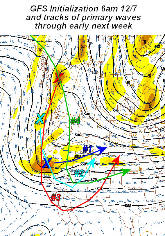
Great Plains Winter Storm Dec 8-10 [post 1]
Slow-moving storm = prolonged winter weather. Here’s the first post of probably many, as another interesting winter storm is developing out over the Southwest. For western Kansas, it appears as if the biggest concern initially will be with freezing drizzle late Friday into Saturday. The first "wave of energy" will prompt snow development from eastern Wyoming into western Nebraska Friday night and Saturday. A shallow cold airmass will ooze south, with sub-freezing temperatures at the surface expected to overspread  Southwest Kansas, including Dodge City. Included in this post is the NAM 36-hr forecast at 750mb (roughly 6500ft above Dodge City elevation) and 900mb (rougly 1100ft above Dodge elevation). Warm air aloft will overspread the shallow cold air at the surface, which is illustrated in Img 1 by the NAM model. Just north of the shallow cold airmass, substantial warm air advection and moisture will allow the development of drizzle/freezing drizzle, depending on the surface temperature.
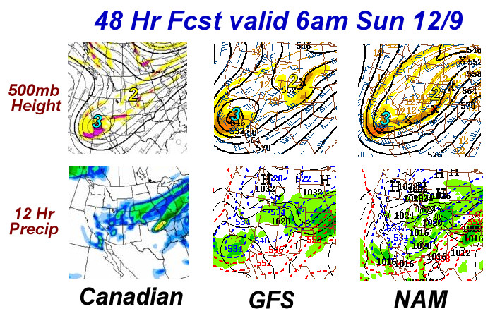
Beyond Saturday, the forecast is real fuzzy, as the upper trough stalls out over the Desert Southwest with smaller scale disturbances rotating around the upper trough axis. The individual mid-upper level jet streaks will dictate the lower level response and subsequent significant precipitation development. From a pattern recognition standpoint, given the configuration of the upper trough with substantial warm air advecting north in the 800-700mb layer coupled with shallow arctic air near the surface, a significant ice storm may be had over some (or a lot!) of the central Plains, including much of Kansas. Img 2 is a 3-panel model comparison among the Canadian, GFS, and NAM at 60 hours valid 6am Sunday 12/9 at 700mb. Here are some of the 12-hour precipitation accumulation from the GFS, NAM, and Canadian models for Dodge City, Saturday through Tuesday:
Model: ending 6pm Sat || 6am Sun || 6pm Sun || 6am Mon || 6pm Mon || 6am Tue || Total
GFS: 0.02 || 0.50 || 0.01 || 0.00 || 0.30 || 0.00 || 0.82
NAM: 0.01 || 0.01 || 0.10 || 0.21 || —- || —- || 0.33
Can: 0.00 || 0.00 || 0.08 || 0.00 || 0.20 || 0.24 || 0.52
*NAM model only goes out to 84 hours.
December 3, 2007
Definition of “Mizzou”
This has nothing to do with storm chasing or photography, but times as a Jayhawker are really good right now…

"They expect me to come home with my tail between my legs, but I won’tdo it. I’d sooner get Mizzou’d out here in the middle of nowhere thanlose face in front of my friends and family again."
"Whoa, whoa. What’d you just say?"
"I said I don’t wanna lose face in front of my friends and family."
"No, before that."
"I- I said I’d sooner get Mizzou’d out here in the middle of nowhere."
"Mizzou’d? What the hell is that?"
"You know, Mizzou’d, uh… to be up a creek without a paddle, to- tohave the whole world in the palm of your hand and then blow it, youknow. It’s a figure of speech."
"Mizzou’d?"
= = J a n u a r y 3 , 2 0 0 8 = =
December 1, 2007
Great Plains Winter Storm Dec 1 [post 7]
So much for appreciable precipitation in SW Kansas. Well, it’s now late morning amidst dense fog here in Dodge City, as surface moisture has rapidly surged north into the remnant shallow cold airmass. The freezing line has shifted way north into Nebraska by now. We observed very light freezing rain and freezing drizzle here in Dodge City from roughly 3:30-6:30am. Total precipitation measured at the airport (from the ASOS) was a whopping 0.01". Up at Hays, it looks like only 0.03" was measured at the AWOS station. Hays went above freezing at roughly 5:30am, several hours sooner than thought. The warm, moist air really surged north rapidly this morning. There were pretty much no impacts across this area from freezing precipitation, as a result. Now we wait on the wind… we’ll see how this aspect of the storm verifies. I was expecting far southwest KS to see some 60 mph gusts later on this afternoon. Now, the real winner (or loser) of this storm from the winter precipitation aspect is Iowa into adjacent southern Minnesota. Major icing going on now across Central Iowa from what it looks like per obs and radar. Here is the Nowcast Thread on Stormtrack forum from other storm chasers and genuine weather weenies talking about that. Back to the high plains region, It’s already 60°F in Lamar, CO from the downslope. Below is the 16z (10am CST) surface chart:
November 30, 2007
Great Plains Winter Storm Dec 1 [post 6]
The dreaded Rain Shadow. This post will be real brief. I’m not liking the new QPF trends from the numerical models for Dodge City and the rest of western Kansas. I attached one image on this post, a 36-hour total precipitation graphic from the NAM model ending 12z (6am) Sunday Dec 2. We will be completely rain-shadowed from the Pacific moisture, which always happens, given the geography. The gulf trajectories and the shape of the low level jet do not favor significant precipitation in western Kansas. Typically, you want to be on the north side of the low level jet, where convergence occurs, to get appreciable precipitation. This will be way northeast of Southwest Kansas. I’ll be surprised if there is even .25" of precipitation over any portion of the western 1/3 of Kansas. There’s nothing on the radar yet, except for in New Mexico as of 930pm CST.

Great Plains Winter Storm Dec 1 [post 5]
 Still in the 20s! It’s cloudy and cold right now in Dodge City with the 3pm temperature of 28°F — a far cry from the lower 40s the GFS and NAM had for highs for us just yesterday. Maybe one of these days, the boundary layer non-hydrostatic physics will improve in the NAM model, and shallow arctic airmasses on the High Plains will be better forecast. So, it’s colder, and also drier, with a dewpoint in the single digits. It’s a no-brainer that our precipitation type tonight will be in the form of freezing rain (maybe some sleet mixed in initially). The question, then, is how much precipitation will we get? At this point I’m thinking about 0.15" of mainly freezing rain here in Dodge City. By the time the expansive precipitation area
  organized later tonight and into tomorrow morning, the "show" will be lifting rapidly northeast of here. The two graphics I present in this post are the 21z (3pm CST) surface observations in Img 1 and the 3-hr forecast of surface temperature and wind from the NAM model in Img 2. As you can see, across pretty much all of western Kansas, the 3-hr forecast (3 hour!!) is off by a significant margin.
Great Plains Winter Storm Dec 1 [post 4]

 Models are too warm! 15z (10am CST) surface observation plot (Img 1) shows the arctic cold front surging south into the Texas Panhandle this morning. Both the GFS and the NAM models are too warm with temperatures behind the front across western Kansas. The GFS model from the 06z ru
 n valid 15z (a 9 hour forecast) was predicting a surface temperature in Dodge City of around 34°F (Img 2), a solid 12 degrees warmer than the actual 15z observation! The NAM 3-hour forecast from the 12z run was showing about 28°F, or about 6 degrees too warm (Img 3). In all three images, I drew in (dotted blue line) the 22°F isotherm to better illustrate the error in the models in handling this shallow arctic airmass.